
Lavalleja topographic map
Interactive map
Click on the map to display elevation.
About this map
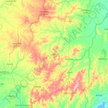
Name: Lavalleja topographic map, elevation, terrain.
Location: Lavalleja, Uruguay (-34.63557 -55.62463 -33.31879 -54.12895)
Average elevation: 446 ft
Minimum elevation: -3 ft
Maximum elevation: 1,594 ft
Other topographic maps
Click on a map to view its topography, its elevation and its terrain.
Cruz de los caminos
Uruguay > Canelones > Cruz de los caminos
Cruz de los caminos, Canelones, 91500, Uruguay
Average elevation: 112 ft
Colonia del Sacramento
Uruguay > Colonia > Colonia del Sacramento
Colonia del Sacramento, Colonia, 70000, Uruguay
Average elevation: 36 ft
Cruz de los Caminos
Uruguay > Tacuarembó > Cruz de los Caminos
Cruz de los Caminos, Tacuarembó, 45000, Uruguay
Average elevation: 459 ft
Punta Del Este
Uruguay > Maldonado > Punta Del Este
Punta Del Este, Maldonado, 20100, Uruguay
Average elevation: 33 ft