
Make a donation
Gear up for your next adventure:
As an Amazon Associate, this site earns from qualifying purchases at no extra cost to you.
Tulancingo de Bravo topographic map
Click on the map to display elevation.
Make a donation
Gear up for your next adventure:
As an Amazon Associate, this site earns from qualifying purchases at no extra cost to you.
Tulancingo de Bravo
It is located in the Trans-Mexican Volcanic Belt in the Sierra Hidalgo, as it begins its descent to the Gulf of Mexico. It is mostly valley floor with some peaks. This relatively flat surface is mostly of light volcanic rock cut with ravines, small canyons, large hills and volcanoes. The larger canyons include Los Ermitaños, which forms a “Y” over one kilometer long. The highest point is the Cerro del Tezontle, named after the volcanic rock it is principally made up of. Other elevations include Cerro Viejo, Napateco and Las Navajas. The main river is the Tulancingo River, which is part of the Metztitlán River system. There are four small lakes called Los Alamos, Otontepec, San Alejo and La Ciénega.
Make a donation
Gear up for your next adventure:
As an Amazon Associate, this site earns from qualifying purchases at no extra cost to you.
About this map
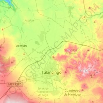
Name: Tulancingo de Bravo topographic map, elevation, terrain.
Location: Tulancingo de Bravo, Hidalgo, Mexico (20.05217 -98.50216 20.21230 -98.24656)
Average elevation: 7,356 ft
Minimum elevation: 6,030 ft
Maximum elevation: 9,032 ft
Make a donation
Gear up for your next adventure:
As an Amazon Associate, this site earns from qualifying purchases at no extra cost to you.
Other topographic maps
Click on a map to view its topography, its elevation and its terrain.
Pachuca
Mexico > Hidalgo > Pachuca de Soto
Pachuca has a semi-arid climate (Köppen climate classification BSk). The climate is cool with high rainfall and occasional hail during the summer months and dry conditions during the winter. The coldest month is January, with an average high of 20 °C (68 °F) and an average low of 3 °C (37 °F). Winter…
Average elevation: 8,068 ft
Make a donation
Gear up for your next adventure:
As an Amazon Associate, this site earns from qualifying purchases at no extra cost to you.
Make a donation
Gear up for your next adventure:
As an Amazon Associate, this site earns from qualifying purchases at no extra cost to you.
Santiago Tulantepec
Mexico > Hidalgo > Santiago Tulantepec de Lugo Guerrero
Average elevation: 7,415 ft
Pachuca
Mexico > Hidalgo > Pachuca de Soto
Pachuca has a semi-arid climate (Köppen climate classification BSk). The climate is cool with high rainfall and occasional hail during the summer months and dry conditions during the winter. The coldest month is January, with an average high of 20 °C (68 °F) and an average low of 3 °C (37 °F). Winter…
Average elevation: 8,068 ft
Make a donation
Gear up for your next adventure:
As an Amazon Associate, this site earns from qualifying purchases at no extra cost to you.
Make a donation
Gear up for your next adventure:
As an Amazon Associate, this site earns from qualifying purchases at no extra cost to you.
Col. Loma Bonita
Mexico > Hidalgo > Atotonilco de Tula > Atotonilco de Tula > Col. Loma Bonita
Average elevation: 7,100 ft
Make a donation
Gear up for your next adventure:
As an Amazon Associate, this site earns from qualifying purchases at no extra cost to you.