Geolocate

Dover topographic map

Click on the map to display elevation.

About this map

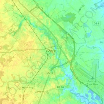
Name: Dover topographic map, elevation, terrain.

Location: Dover, Kent County, Delaware, United States (39.10220 -75.58620 39.21025 -75.44073)

Average elevation: 33 ft

Minimum elevation: -16 ft

Maximum elevation: 62 ft

Kent County trails, hiking, mountain biking, running and outdoor activities

Other topographic maps

Click on a map to view its topography, its elevation and its terrain.

Lebanon

United States > Delaware > Kent County > Highland Acres

Average elevation: 23 ft

Vernon

United States > Delaware > Kent County

Average elevation: 52 ft

Dover Base

United States > Delaware > Kent County

Average elevation: 16 ft

Lebanon

United States > Delaware > Kent County > Highland Acres

Average elevation: 23 ft

Holletts Corners

United States > Delaware > Kent County

Average elevation: 69 ft

Woodstock Court

United States > Delaware > Kent County > Dover

Average elevation: 43 ft

Marydel

United States > Delaware > Kent County

Average elevation: 62 ft

Lake Bernard

United States > Delaware > Kent County > Florence

Average elevation: 13 ft

Gear up for your next adventure:

🪶Trail Camera - Capture wildlife on your hikes
📶Vehicle Signal Boosters - Improve reception in rural areas while driving to trailheads
🦶Hiking Gaiters - Keep debris and water out of your boots
🧭GPS Watch Accessories - Bands and chargers for GPS watches
🔊Portable Camp Speaker - Music and alerts at camp

As an Amazon Associate, this site earns from qualifying purchases at no extra cost to you.