Geolocate

Ima topographic map

Click on the map to display elevation.

About this map

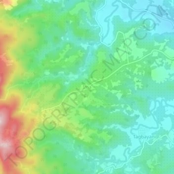
Name: Ima topographic map, elevation, terrain.

Location: Ima, Surigao del Norte, Caraga, 8404, Philippines (9.64342 125.45842 9.68342 125.49842)

Average elevation: 335 ft

Minimum elevation: 66 ft

Maximum elevation: 965 ft

Other topographic maps

Click on a map to view its topography, its elevation and its terrain.

Siargao

Philippines > Surigao Del Norte

Average elevation: 36 ft

Mayag River

Philippines > Surigao Del Norte > Cantugas

Average elevation: 597 ft

Burgos

Philippines > Surigao Del Norte

Average elevation: 98 ft

Alegria

Philippines > Surigao Del Norte

Average elevation: 709 ft

San Isidro

Philippines > Surigao Del Norte > San Isidro

Average elevation: 89 ft

Gear up for your next adventure:

🔭Telescopic Hiking Pole - Adjustable pole for hiking stability
👟Trail Running Shoes - Lightweight shoes for trail runners
🧯Emergency Survival Kit - All‑in‑one survival essentials for the backcountry
🥩Freeze-Dried Meals - Nutritious and lightweight food for remote expeditions
🌡️Portable Weather Meter - Track weather conditions on the trail

As an Amazon Associate, this site earns from qualifying purchases at no extra cost to you.