Geolocate

Safaga topographic map

Click on the map to display elevation.

About this map

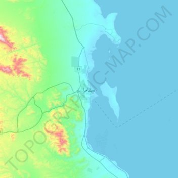
Name: Safaga topographic map, elevation, terrain.

Location: Safaga, Red Sea, 84711, Egypt (26.60333 33.77838 26.92333 34.09838)

Average elevation: 410 ft

Minimum elevation: 0 ft

Maximum elevation: 3,386 ft

Other topographic maps

Click on a map to view its topography, its elevation and its terrain.

Gulf of Suez

Egypt > Red Sea

Average elevation: 1,578 ft

Al Hadaba

Egypt > Red Sea

Average elevation: 135 ft

Al Hadaba

Egypt > Red Sea

Average elevation: 135 ft

Industrial Area

Egypt > Red Sea

Average elevation: 125 ft

Wadi Gemal

Egypt > Red Sea

Average elevation: 1,227 ft

Safaja

Egypt > Red Sea

Average elevation: 3 ft

Gulf of Suez

Egypt > Red Sea

Average elevation: 1,578 ft

Marsa Alam City

Egypt > Red Sea

Average elevation: 62 ft

Gamsha

Egypt > Red Sea

Average elevation: 154 ft

Geziret Tubya

Egypt > Red Sea > Safaja

Average elevation: 0 ft

Al Ahia'

Egypt > Red Sea

Average elevation: 52 ft

Al Qusair City

Egypt > Red Sea

Average elevation: 154 ft

Industrial Area

Egypt > Red Sea

Average elevation: 125 ft

Fresh water pool, cold

Egypt > Red Sea > Al Qusair City

Average elevation: 26 ft

Al Ahia'

Egypt > Red Sea

Average elevation: 52 ft

Gear up for your next adventure:

🧭Hiking Compass - Precision compass for reliable navigation in the wilderness
🥾Women's Hiking Boots - Top-rated trail boots with ankle support and superior grip
👓Polarized Sunglasses - Outdoor sunglasses for glare reduction
🧯Portable Fire Pit - Compact fire pit for camping spots
Backpacking Tents - Weight-optimized shelters for multi-day topographic surveys

As an Amazon Associate, this site earns from qualifying purchases at no extra cost to you.