Geolocate

Alpha topographic map

Click on the map to display elevation.

About this map

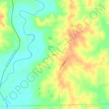
Name: Alpha topographic map, elevation, terrain.

Location: Alpha, Grundy County, Missouri, 64652, United States (39.96530 -93.44105 40.00530 -93.40105)

Average elevation: 797 ft

Minimum elevation: 728 ft

Maximum elevation: 873 ft

Grundy County trails, hiking, mountain biking, running and outdoor activities

Other topographic maps

Click on a map to view its topography, its elevation and its terrain.

Galt

United States > Missouri > Grundy County

Average elevation: 830 ft

Laredo

United States > Missouri > Grundy County

Average elevation: 801 ft

Tindall

United States > Missouri > Grundy County

Average elevation: 814 ft

Brimson

United States > Missouri > Grundy County

Average elevation: 797 ft

Gear up for your next adventure:

🔭Stargazing Telescopes - Perfect for camping in low-light pollution areas shown on maps
🗻Climbing Gear Basics - Essential gear for beginner climbers
📚USA Hiking Guide Books - Top trail guides and map books
🔌USB Car Charger - Car charger for on‑the‑go power needs
☀️Outdoor Sunscreen - High protection sunscreen for outdoor activities

As an Amazon Associate, this site earns from qualifying purchases at no extra cost to you.