Geolocate

Paradela topographic map

Click on the map to display elevation.

About this map

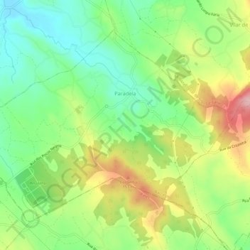
Name: Paradela topographic map, elevation, terrain.

Location: Paradela, Barcelos, Braga, 4755-377, Portugal (41.44216 -8.71179 41.47310 -8.65843)

Average elevation: 256 ft

Minimum elevation: 13 ft

Maximum elevation: 614 ft

Other topographic maps

Click on a map to view its topography, its elevation and its terrain.

Vila Cova

Portugal > Braga > Barcelos

Average elevation: 322 ft

Franqueira

Portugal > Braga > Barcelos

Average elevation: 479 ft

Silveiros

Portugal > Braga > Barcelos

Average elevation: 446 ft

Fonte Coberta

Portugal > Braga > Barcelos

Average elevation: 384 ft

Monte do Facho

Portugal > Braga > Barcelos > Roriz

Average elevation: 397 ft

Feitos

Portugal > Braga > Barcelos

Average elevation: 850 ft

Milhazes

Portugal > Braga > Barcelos

Average elevation: 272 ft

Vilar do Monte

Portugal > Braga > Barcelos

Average elevation: 541 ft

Gonçalo

Portugal > Braga > Barcelos

Average elevation: 1,138 ft

Martim de Além

Portugal > Braga > Barcelos > Martim

Average elevation: 440 ft

Durrães

Portugal > Braga > Barcelos

Average elevation: 433 ft

Gear up for your next adventure:

🧥Men's Rain Shells - Premium waterproof and breathable jackets for mountain weather
🛡️Bear Spray Outdoor - Protection in bear country hikes
📷Action Cameras - Rugged cameras to document your journeys across rugged terrain
🛰️Satellite Messengers - Emergency SOS and two-way messaging for off-grid adventures
🚗GPS Dash Cams - Record your scenic drives through mountain passes and canyons

As an Amazon Associate, this site earns from qualifying purchases at no extra cost to you.