Geolocate

Jordan topographic map

Click on the map to display elevation.

About this map

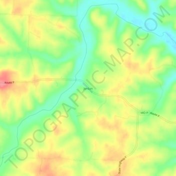
Name: Jordan topographic map, elevation, terrain.

Location: Jordan, Hickory County, Missouri, United States (38.00142 -93.16131 38.04142 -93.12131)

Average elevation: 909 ft

Minimum elevation: 774 ft

Maximum elevation: 1,053 ft

Hickory County trails, hiking, mountain biking, running and outdoor activities

Other topographic maps

Click on a map to view its topography, its elevation and its terrain.

Weaubleau

United States > Missouri > Hickory County

Average elevation: 974 ft

Wheatland

United States > Missouri > Hickory County

Average elevation: 1,047 ft

Cross Timbers

United States > Missouri > Hickory County

Average elevation: 994 ft

Hermitage

United States > Missouri > Hickory County

Average elevation: 820 ft

Preston

United States > Missouri > Hickory County

Average elevation: 1,020 ft

Gear up for your next adventure:

📻Weather Alert Radios - Stay informed of storm risks while off-the-grid
🌡️Portable Weather Meter - Track weather conditions on the trail
🗺️NatGeo Topo Maps - High-quality waterproof printed topographic maps of US Parks
🔋Rechargeable Batteries - Power up your outdoor devices
🔥Camping Stove - Portable stove for camping and backcountry cooking

As an Amazon Associate, this site earns from qualifying purchases at no extra cost to you.