
Make a donation
Gear up for your next adventure:
As an Amazon Associate, this site earns from qualifying purchases at no extra cost to you.
Andoversford topographic map
Click on the map to display elevation.
Make a donation
Gear up for your next adventure:
As an Amazon Associate, this site earns from qualifying purchases at no extra cost to you.
About this map
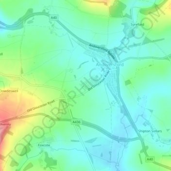
Name: Andoversford topographic map, elevation, terrain.
Average elevation: 617 ft
Minimum elevation: 518 ft
Maximum elevation: 869 ft
Make a donation
Gear up for your next adventure:
As an Amazon Associate, this site earns from qualifying purchases at no extra cost to you.
Other topographic maps
Click on a map to view its topography, its elevation and its terrain.
Duntisbourne Abbots
United Kingdom > England > Gloucestershire > Cotswold District
Average elevation: 669 ft
Stow-on-the-Wold
United Kingdom > England > Gloucestershire > Cotswold District
Average elevation: 535 ft
Lower Slaughter
United Kingdom > England > Gloucestershire > Cotswold District
Average elevation: 525 ft
Make a donation
Gear up for your next adventure:
As an Amazon Associate, this site earns from qualifying purchases at no extra cost to you.
Calcot
United Kingdom > England > Gloucestershire > Cotswold District > Coln Rogers
Average elevation: 495 ft
Make a donation
Gear up for your next adventure:
As an Amazon Associate, this site earns from qualifying purchases at no extra cost to you.
Caudle Green
United Kingdom > England > Gloucestershire > Cotswold District > Brimpsfield
Average elevation: 768 ft
Botany Bay Wood
United Kingdom > England > Gloucestershire > Cotswold District > Stow-on-the-Wold
Average elevation: 561 ft
Make a donation
Gear up for your next adventure:
As an Amazon Associate, this site earns from qualifying purchases at no extra cost to you.
Trewsbury Mead
United Kingdom > England > Gloucestershire > Cotswold District
Average elevation: 400 ft
Make a donation
Gear up for your next adventure:
As an Amazon Associate, this site earns from qualifying purchases at no extra cost to you.
Make a donation
Gear up for your next adventure:
As an Amazon Associate, this site earns from qualifying purchases at no extra cost to you.
Shipton Oliffe
United Kingdom > England > Gloucestershire > Cotswold District > Shipton
Average elevation: 659 ft
Make a donation
Gear up for your next adventure:
As an Amazon Associate, this site earns from qualifying purchases at no extra cost to you.
Make a donation
Gear up for your next adventure:
As an Amazon Associate, this site earns from qualifying purchases at no extra cost to you.
Seven Springs
United Kingdom > England > Gloucestershire > Cotswold District > Coberley
Average elevation: 774 ft
Make a donation
Gear up for your next adventure:
As an Amazon Associate, this site earns from qualifying purchases at no extra cost to you.
Bourton-on-the-Hill
United Kingdom > England > Gloucestershire > Cotswold District
Average elevation: 643 ft
Bushley Muzzard, Brimpsfield
United Kingdom > England > Gloucestershire > Cotswold District > Nettleton > Watercombe
Average elevation: 856 ft
Make a donation
Gear up for your next adventure:
As an Amazon Associate, this site earns from qualifying purchases at no extra cost to you.
Ampney Crucis
United Kingdom > England > Gloucestershire > Cotswold District
Average elevation: 374 ft
Make a donation
Gear up for your next adventure:
As an Amazon Associate, this site earns from qualifying purchases at no extra cost to you.
Bledington
United Kingdom > England > Gloucestershire > Cotswold District > Bledington
Average elevation: 387 ft
Upper Oddington
United Kingdom > England > Gloucestershire > Cotswold District
Average elevation: 440 ft
Make a donation
Gear up for your next adventure:
As an Amazon Associate, this site earns from qualifying purchases at no extra cost to you.
Ablington
United Kingdom > England > Gloucestershire > Cotswold District > Ablington
Average elevation: 446 ft
Meysey Hampton
United Kingdom > England > Gloucestershire > Cotswold District
Average elevation: 315 ft
Make a donation
Gear up for your next adventure:
As an Amazon Associate, this site earns from qualifying purchases at no extra cost to you.
Winstone
United Kingdom > England > Gloucestershire > Cotswold District > Winstone
Average elevation: 728 ft
Paxford
United Kingdom > England > Gloucestershire > Cotswold District > Paxford
Average elevation: 407 ft
Weston-sub-Edge
United Kingdom > England > Gloucestershire > Cotswold District
Average elevation: 322 ft
Broad Campden
United Kingdom > England > Gloucestershire > Cotswold District
Average elevation: 548 ft
Make a donation
Gear up for your next adventure:
As an Amazon Associate, this site earns from qualifying purchases at no extra cost to you.
Compton Abdale
United Kingdom > England > Gloucestershire > Cotswold District
Average elevation: 696 ft
Knap House Quarry, Birdlip
United Kingdom > England > Gloucestershire > Cotswold District > Birdlip
Average elevation: 728 ft
Somerford Keynes
United Kingdom > England > Gloucestershire > Cotswold District
Average elevation: 299 ft
Make a donation
Gear up for your next adventure:
As an Amazon Associate, this site earns from qualifying purchases at no extra cost to you.
Eastleach Martin
United Kingdom > England > Gloucestershire > Cotswold District > Eastleach Turville
Average elevation: 364 ft
Crickley Hill
United Kingdom > England > Gloucestershire > Cotswold District
Average elevation: 666 ft
Make a donation
Gear up for your next adventure:
As an Amazon Associate, this site earns from qualifying purchases at no extra cost to you.