Geolocate

Williamson Valley Wash topographic map

Interactive map

Click on the map to display elevation.

About this map

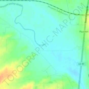
Name: Williamson Valley Wash topographic map, elevation, terrain.

Location: Williamson Valley Wash, Yavapai County, Arizona, United States (34.88151 -112.48340 34.88181 -112.48243)

Average elevation: 4,386 ft

Minimum elevation: 4,347 ft

Maximum elevation: 4,472 ft

Yavapai County trails, hiking, mountain biking, running and outdoor activities

Other topographic maps

Click on a map to view its topography, its elevation and its terrain.

Seligman

United States > Arizona > Yavapai County > Seligman

Seligman is located at 35°19′42″N 112°52′27″W / 35.32833°N 112.87417°W / 35.32833; -112.87417 (35.328199, −112.874303), at 5,240 feet (1,600 m) in elevation, alongside the Big Chino Wash, in a northern section of Chino Valley. The wash is a major tributary of the Verde River. Seligman is…

Average elevation: 5,305 ft

Cleator

United States > Arizona > Yavapai County

Average elevation: 3,553 ft

Dewey-Humboldt

United States > Arizona > Yavapai County

Average elevation: 4,803 ft

Ash Fork

United States > Arizona > Yavapai County

Average elevation: 5,171 ft

Glen Oaks

United States > Arizona > Yavapai County

Average elevation: 5,633 ft

Walker

United States > Arizona > Yavapai County

Average elevation: 6,690 ft

Big Park

United States > Arizona > Yavapai County

Average elevation: 4,373 ft

Yarnell

United States > Arizona > Yavapai County

Average elevation: 4,823 ft

Skull Valley

United States > Arizona > Yavapai County

Average elevation: 4,403 ft

Tapco

United States > Arizona > Yavapai County

Average elevation: 3,553 ft

Rimrock

United States > Arizona > Yavapai County

Average elevation: 3,583 ft

Lake Montezuma

United States > Arizona > Yavapai County > Rimrock

Average elevation: 3,527 ft

Verde Village

United States > Arizona > Yavapai County

Average elevation: 3,412 ft

Black Canyon City

United States > Arizona > Yavapai County

Black Canyon City is located at 34°4′11″N 112°8′22″W / 34.06972°N 112.13944°W / 34.06972; -112.13944 (34.069719, -112.139466), at an elevation of 1,975 feet (602 m).

Average elevation: 2,297 ft

Clarkdale

United States > Arizona > Yavapai County

Average elevation: 3,973 ft

Lake Pleasant

United States > Arizona > Yavapai County > Peoria

Average elevation: 1,854 ft

Perkinsville

United States > Arizona > Yavapai County

Average elevation: 4,121 ft

Chimney Rock

United States > Arizona > Yavapai County

Average elevation: 4,728 ft

Kirkland

United States > Arizona > Yavapai County

Average elevation: 4,029 ft

Paulden

United States > Arizona > Yavapai County

Average elevation: 4,619 ft

Paradise Acres

United States > Arizona > Yavapai County > Camp Verde

Average elevation: 3,110 ft

Arcosanti

United States > Arizona > Yavapai County

Arcosanti is a projected experimental town with a bronze bell casting business in Yavapai County, central Arizona, United States, 70 mi (110 km) north of Phoenix, at an elevation of 3,732 feet (1,138 m). Its arcology concept was proposed by Italian-American architect Paolo Soleri (1919–2013). He began…

Average elevation: 3,707 ft

Jerome

United States > Arizona > Yavapai County

Jerome is about 100 miles (160 km) north of Phoenix and 45 miles (72 km) southwest of Flagstaff along Arizona State Route 89A between Sedona to the east and Prescott to the west. The town is in Arizona's Black Hills, which trend north–south. The town lies within the Prescott National Forest at an elevation…

Average elevation: 5,164 ft

Mayer

United States > Arizona > Yavapai County

Average elevation: 4,682 ft

Ocotillo

United States > Arizona > Yavapai County

Average elevation: 4,272 ft

Cedar Bench Wilderness

United States > Arizona > Yavapai County

Cedar Bench Wilderness is a protected wilderness area in the Prescott National Forest in the U.S. state of Arizona. Established in 1984 under the Arizona Wilderness Act, the area protects the large "bench" that divides the Agua Fria and Verde River drainages. Elevations range from 4,500 feet (1,371 m) to 6,700…

Average elevation: 4,426 ft

Clear Creek

United States > Arizona > Yavapai County > Camp Verde

Average elevation: 3,130 ft

Miller Valley

United States > Arizona > Yavapai County > Prescott

Average elevation: 5,456 ft

Granite Mountain

United States > Arizona > Yavapai County

Average elevation: 6,283 ft

Crown King

United States > Arizona > Yavapai County

Average elevation: 6,240 ft

Willow Spring

United States > Arizona > Yavapai County

Average elevation: 4,747 ft

Yava

United States > Arizona > Yavapai County

Average elevation: 3,593 ft

Agua Fria National Monument

United States > Arizona > Yavapai County

Situated between 2,150 feet (660 m) and 4,600 feet (1,400 m) in elevation, the monument is primarily composed of semi-desert grassland but also contains extensive riparian stands of cottonwoods and willows which are tied to the Agua Fria River. More than 140 bird species have been recorded at the monument.

Average elevation: 3,809 ft

House Mountain

United States > Arizona > Yavapai County

Average elevation: 4,649 ft

Briggs

United States > Arizona > Yavapai County

Average elevation: 3,084 ft

Woodchute Mountain

United States > Arizona > Yavapai County

Average elevation: 7,110 ft

Cornville

United States > Arizona > Yavapai County

Average elevation: 3,704 ft