Geolocate

Crouch topographic map

Click on the map to display elevation.

About this map

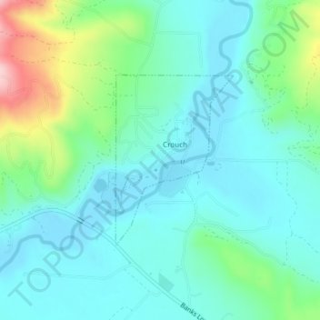
Name: Crouch topographic map, elevation, terrain.

Location: Crouch, Boise County, Idaho, United States (44.10664 -115.97792 44.12103 -115.96409)

Average elevation: 3,159 ft

Minimum elevation: 3,012 ft

Maximum elevation: 3,665 ft

Boise County trails, hiking, mountain biking, running and outdoor activities

Other topographic maps

Click on a map to view its topography, its elevation and its terrain.

Lowman

United States > Idaho > Boise County

Average elevation: 4,469 ft

Centerville

United States > Idaho > Boise County

Average elevation: 4,318 ft

Robie Creek

United States > Idaho > Boise County

Average elevation: 3,658 ft

Placerville

United States > Idaho > Boise County

Average elevation: 4,406 ft

Hawley Mountain

United States > Idaho > Boise County

Average elevation: 6,637 ft

North Raker

United States > Idaho > Boise County

Average elevation: 8,698 ft

Gear up for your next adventure:

🌡️Portable Weather Meter - Track weather conditions on the trail
🍳Camping Cook Set - Complete cookware for outdoor meals
🪶Trail Camera - Capture wildlife on your hikes
🏕️Family Camping Gear - Essentials for group camping trips
🪶Paracord Bracelet - Survival bracelet with built‑in tools

As an Amazon Associate, this site earns from qualifying purchases at no extra cost to you.