Geolocate

Eltopia topographic map

Click on the map to display elevation.

About this map

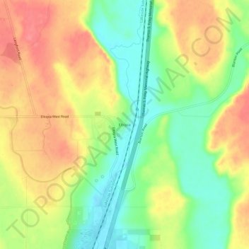
Name: Eltopia topographic map, elevation, terrain.

Location: Eltopia, Franklin County, Washington, United States (46.43875 -119.03723 46.47875 -118.99723)

Average elevation: 692 ft

Minimum elevation: 571 ft

Maximum elevation: 810 ft

Franklin County trails, hiking, mountain biking, running and outdoor activities

Other topographic maps

Click on a map to view its topography, its elevation and its terrain.

Basin City

United States > Washington > Franklin County

Average elevation: 725 ft

West Pasco

United States > Washington > Franklin County

Average elevation: 390 ft

Mesa

United States > Washington > Franklin County

Average elevation: 784 ft

Pasco

United States > Washington > Franklin County > Pasco

Average elevation: 541 ft

Gear up for your next adventure:

🔭Telescopic Hiking Pole - Adjustable pole for hiking stability
🌧️Backpack Rain Cover - Keep gear dry in wet weather
🧤Tactile Hiking Gloves - Keep hands warm while operating GPS and smartphone screens
🌲Outdoor Survival Books - Best books on survival skills
🧭Hiking Compass - Precision compass for reliable navigation in the wilderness

As an Amazon Associate, this site earns from qualifying purchases at no extra cost to you.