Geolocate

Mesa topographic map

Click on the map to display elevation.

About this map

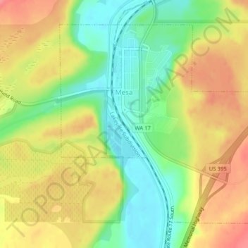
Name: Mesa topographic map, elevation, terrain.

Location: Mesa, Franklin County, Washington, United States (46.56196 -119.01689 46.58363 -118.98554)

Average elevation: 784 ft

Minimum elevation: 656 ft

Maximum elevation: 912 ft

Franklin County trails, hiking, mountain biking, running and outdoor activities

Other topographic maps

Click on a map to view its topography, its elevation and its terrain.

Harder

United States > Washington > Franklin County

Average elevation: 1,148 ft

Farrington

United States > Washington > Franklin County

Average elevation: 965 ft

Eltopia

United States > Washington > Franklin County

Average elevation: 692 ft

Gear up for your next adventure:

🥘Titanium Cookware - Durable, featherlight pots and pans for backpacking
🔭Stargazing Telescopes - Perfect for camping in low-light pollution areas shown on maps
🧷Carabiner Set - Durable clips for gear attachment
🌲Outdoor Survival Books - Best books on survival skills
📦Dry Bags Set - Waterproof storage for electronics and clothes

As an Amazon Associate, this site earns from qualifying purchases at no extra cost to you.