
Tumbler Ridge topographic map
Click on the map to display elevation.
About this map
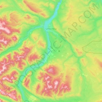
Name: Tumbler Ridge topographic map, elevation, terrain.
Average elevation: 3,783 ft
Minimum elevation: 2,290 ft
Maximum elevation: 6,755 ft
Other topographic maps
Click on a map to view its topography, its elevation and its terrain.
Tsay Keh Dene Nation
Canada > British Columbia > Peace River Regional District > Area B (Finlay Valley/Beatton Valley)
Average elevation: 2,257 ft
Van Somer Point
Canada > British Columbia > Peace River Regional District > Area B (Finlay Valley/Beatton Valley)
Average elevation: 2,198 ft
Black Bear Ridge
Canada > British Columbia > Peace River Regional District > Area B (Finlay Valley/Beatton Valley)
Average elevation: 4,311 ft
Carbon Peak
Canada > British Columbia > Peace River Regional District > Area E (Moberly Lake/Sukunka Valley)
Average elevation: 4,662 ft
Mount Hermann
Canada > British Columbia > Peace River Regional District > Tumbler Ridge
Average elevation: 4,721 ft
Dawson Creek
Canada > British Columbia > Peace River Regional District > Dawson Creek
Average elevation: 2,425 ft
Reef Canyon
Canada > British Columbia > Peace River Regional District > Area B (Finlay Valley/Beatton Valley)
Average elevation: 3,632 ft