Geolocate

Treece topographic map

Click on the map to display elevation.

About this map

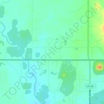
Name: Treece topographic map, elevation, terrain.

Location: Treece, Cherokee County, Kansas, 66778, United States (36.99090 -94.85328 37.01090 -94.83328)

Average elevation: 843 ft

Minimum elevation: 810 ft

Maximum elevation: 938 ft

Cherokee County trails, hiking, mountain biking, running and outdoor activities

Other topographic maps

Click on a map to view its topography, its elevation and its terrain.

Scammon

United States > Kansas > Cherokee County

Average elevation: 915 ft

West Mineral

United States > Kansas > Cherokee County

Average elevation: 896 ft

Lowell

United States > Kansas > Cherokee County

Average elevation: 814 ft

Roseland

United States > Kansas > Cherokee County

Average elevation: 912 ft

Galena

United States > Kansas > Cherokee County

Average elevation: 925 ft

Gear up for your next adventure:

🛶Inflatable Kayak - Portable kayak for rivers, lakes, and expeditions
🔥Fast-Boil Camping Stoves - Efficient cooking systems for quick trail meals
💧Water Purification System - Clean water on the trail with reliable purifiers
🕶️Glacier Sunglasses - Side shields to protect eyes from high-altitude snow glare
🛡️Bear Spray Outdoor - Protection in bear country hikes

As an Amazon Associate, this site earns from qualifying purchases at no extra cost to you.