Geolocate

Scammon topographic map

Click on the map to display elevation.

About this map

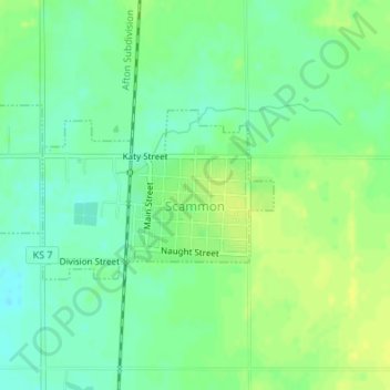
Name: Scammon topographic map, elevation, terrain.

Location: Scammon, Cherokee County, Kansas, United States (37.27270 -94.83217 37.28445 -94.81201)

Average elevation: 915 ft

Minimum elevation: 883 ft

Maximum elevation: 942 ft

Cherokee County trails, hiking, mountain biking, running and outdoor activities

Other topographic maps

Click on a map to view its topography, its elevation and its terrain.

Lowell

United States > Kansas > Cherokee County

Average elevation: 814 ft

Riverton

United States > Kansas > Cherokee County

Average elevation: 833 ft

Treece

United States > Kansas > Cherokee County

Average elevation: 843 ft

Gear up for your next adventure:

🪶Paracord Bracelet - Survival bracelet with built‑in tools
🛶Inflatable Kayak - Portable kayak for rivers, lakes, and expeditions
🧭Hiking Compass - Precision compass for reliable navigation in the wilderness
⛑️Personal Locator Beacon - Safety beacon for emergencies
🎒Hydration Pack - Hands‑free water reservoir for long hikes

As an Amazon Associate, this site earns from qualifying purchases at no extra cost to you.