Geolocate

Diamond Ridge topographic map

Click on the map to display elevation.

Diamond Ridge

The community is named for the high ground, Diamond Ridge, on which it sits. The ridge reaches an elevation of 1,202 feet (366 m) above sea level and is in the southern part of the CDP. Parallel landforms to the north are Crossman Ridge in the center of the CDP and a ridge connecting 1,513-foot (461 m) Ohlson Mountain and 1,622-foot (494 m) Lookout Mountain in the north. The terrain slopes north from the ridges to the Anchor River, which forms the northern boundary of the CDP.

Wikipedia (CC-BY-SA 3.0)

About this map

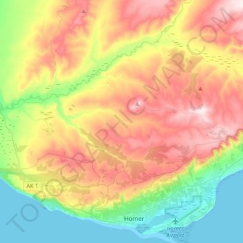
Name: Diamond Ridge topographic map, elevation, terrain.

Location: Diamond Ridge, Kenai Peninsula, Alaska, United States (59.65347 -151.70604 59.75272 -151.41287)

Average elevation: 699 ft

Minimum elevation: 0 ft

Maximum elevation: 1,621 ft

Kenai Peninsula trails, hiking, mountain biking, running and outdoor activities

Other topographic maps

Click on a map to view its topography, its elevation and its terrain.

Aialik Bay

United States > Alaska > Kenai Peninsula

Average elevation: 0 ft

Homer

United States > Alaska > Kenai Peninsula > Homer

Some birds seen during the spring migration and the festival include horned puffins, sandhill cranes, and arctic terns. Arctic Terns are famous for flying the longest distance of any migrating bird. Many of the birds seen during the festival can be identified with the help of published guides that categorize…

Average elevation: 348 ft

Tustumena Lake

United States > Alaska > Kenai Peninsula

Average elevation: 646 ft

Cook Inlet

United States > Alaska > Kenai Peninsula

Average elevation: 0 ft

Kachemak City

United States > Alaska > Kenai Peninsula

Average elevation: 351 ft

Seldovia

United States > Alaska > Kenai Peninsula > Seldovia

Average elevation: 240 ft

Seldovia

United States > Alaska > Kenai Peninsula

Average elevation: 141 ft

Grewingk Glacier

United States > Alaska > Kenai Peninsula

Average elevation: 3,376 ft

Turnagain Arm

United States > Alaska > Kenai Peninsula

Average elevation: 1,184 ft

Seward

United States > Alaska > Kenai Peninsula

Average elevation: 922 ft

Ninilchik

United States > Alaska > Kenai Peninsula

Average elevation: 689 ft

Soldotna

United States > Alaska > Kenai Peninsula > Soldotna

Average elevation: 207 ft

Finger Lakes

United States > Alaska > Kenai Peninsula

Average elevation: 249 ft

Gear up for your next adventure:

🗺️Topographic Maps - Detailed topo maps for hiking, exploring and outdoor navigation
🪶Fire Starter Kit - Reliable fire starter for survival and camping
🦟Ultrasonic Repellers - Create a bug-free zone at your camp or rest stop
🧭Orienteering Set - Complete compass and map reading kit
📡GPS Antenna Upgrade - Enhance GPS reception in remote terrain

As an Amazon Associate, this site earns from qualifying purchases at no extra cost to you.