
Ossipee topographic map
Click on the map to display elevation.
Ossipee
The two primary settlements in town are Center Ossipee, located near the southern junction of routes 16 and 25, and Ossipee Corner (shown as "Ossipee" on topographic maps), located 5 miles (8 km) south of Center Ossipee at the junction of routes 28 and 171 and close to Route 16. Other villages include West Ossipee, at the northern junction of routes 16 and 25 near the border with Tamworth; Moultonville, directly west of Center Ossipee; and Water Village, along Route 171 near the border with Tuftonboro.
About this map
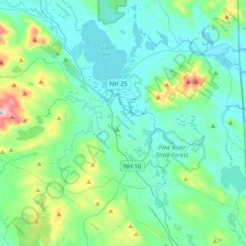
Name: Ossipee topographic map, elevation, terrain.
Location: Ossipee, Carroll County, New Hampshire, United States (43.63642 -71.28572 43.83303 -71.01360)
Average elevation: 794 ft
Minimum elevation: 374 ft
Maximum elevation: 2,927 ft
Carroll County trails, hiking, mountain biking, running and outdoor activities
Other topographic maps
Click on a map to view its topography, its elevation and its terrain.
Winnipesaukee
United States > New Hampshire > Carroll County > Moultonborough
Average elevation: 528 ft
Little Bear Island
United States > New Hampshire > Carroll County > Tuftonboro
Average elevation: 525 ft
Black Cat Island
United States > New Hampshire > Carroll County > Moultonborough
Average elevation: 512 ft
Nineacre Island
United States > New Hampshire > Carroll County > Moultonborough
Average elevation: 518 ft
Whortleberry Island
United States > New Hampshire > Carroll County > Tuftonboro > Chase Point
Average elevation: 512 ft
Cow Island
United States > New Hampshire > Carroll County > Tuftonboro > Fox Point
Average elevation: 531 ft
Castle in the Clouds
United States > New Hampshire > Carroll County > Moultonborough
Average elevation: 1,191 ft
Mirror Lake
United States > New Hampshire > Carroll County > Tuftonboro > Mirror Lake
Average elevation: 554 ft
Winnipesaukee
United States > New Hampshire > Carroll County > Moultonborough
Average elevation: 528 ft
Mount Roberts
United States > New Hampshire > Carroll County > Moultonborough
Average elevation: 2,005 ft
Whortleberry Island
United States > New Hampshire > Carroll County > Tuftonboro > Chase Point
Average elevation: 512 ft
Albany
United States > New Hampshire > Carroll County > Albany
According to the United States Census Bureau, the town has a total area of 75.8 square miles (196.2 km2), of which 75.1 square miles (194.6 km2) are land and 0.58 square miles (1.5 km2) are water, comprising 0.79% of the town. It is drained by the Swift River in the north and the Chocorua River in the south.…
Average elevation: 906 ft