
Make a donation
Gear up for your next adventure:
As an Amazon Associate, this site earns from qualifying purchases at no extra cost to you.
eMalahleni topographic map
Click on the map to display elevation.
Make a donation
Gear up for your next adventure:
As an Amazon Associate, this site earns from qualifying purchases at no extra cost to you.
About this map
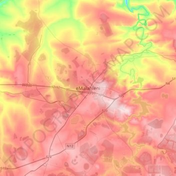
Name: eMalahleni topographic map, elevation, terrain.
Average elevation: 4,987 ft
Minimum elevation: 4,370 ft
Maximum elevation: 5,394 ft
Make a donation
Gear up for your next adventure:
As an Amazon Associate, this site earns from qualifying purchases at no extra cost to you.
Other topographic maps
Click on a map to view its topography, its elevation and its terrain.
Rietfontein Dam
South Africa > Mpumalanga > Nkangala > Emalahleni Local Municipality
Average elevation: 5,141 ft
Loskop Dam
South Africa > Mpumalanga > Nkangala > Steve Tshwete Local Municipality
Average elevation: 3,973 ft
Make a donation
Gear up for your next adventure:
As an Amazon Associate, this site earns from qualifying purchases at no extra cost to you.
Middelburg Dam
South Africa > Mpumalanga > Nkangala > Steve Tshwete Local Municipality
Average elevation: 5,062 ft
Steve Tshwete Ward 11
South Africa > Mpumalanga > Nkangala > Steve Tshwete Local Municipality
Average elevation: 4,987 ft
Make a donation
Gear up for your next adventure:
As an Amazon Associate, this site earns from qualifying purchases at no extra cost to you.
Dr JS Moroka Ward 29
South Africa > Mpumalanga > Nkangala > Dr JS Moroka Local Municipality
Average elevation: 3,432 ft
Kranspoort Dam
South Africa > Mpumalanga > Nkangala > Steve Tshwete Local Municipality
Average elevation: 3,593 ft
Dr JS Moroka Ward 13
South Africa > Mpumalanga > Nkangala > Dr JS Moroka Local Municipality
Average elevation: 3,402 ft
Make a donation
Gear up for your next adventure:
As an Amazon Associate, this site earns from qualifying purchases at no extra cost to you.
Emgwenya (Waterval Boven)
South Africa > Mpumalanga > Nkangala > Emakhazeni Local Municipality
Average elevation: 4,672 ft
Steve Tshwete Ward 11
South Africa > Mpumalanga > Nkangala > Steve Tshwete Local Municipality
Average elevation: 4,987 ft
Make a donation
Gear up for your next adventure:
As an Amazon Associate, this site earns from qualifying purchases at no extra cost to you.
Leratong Stream
South Africa > Mpumalanga > Nkangala > Thembisile Hani Local Municipality > KwaMhlanga
Average elevation: 4,295 ft
Make a donation
Gear up for your next adventure:
As an Amazon Associate, this site earns from qualifying purchases at no extra cost to you.
Emakhazeni Local Municipality
South Africa > Mpumalanga > Nkangala > Emakhazeni Local Municipality
Average elevation: 5,180 ft