
Make a donation
Gear up for your next adventure:
As an Amazon Associate, this site earns from qualifying purchases at no extra cost to you.
Emalahleni Local Municipality topographic map
Click on the map to display elevation.
Make a donation
Gear up for your next adventure:
As an Amazon Associate, this site earns from qualifying purchases at no extra cost to you.
About this map
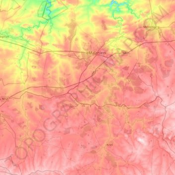
Name: Emalahleni Local Municipality topographic map, elevation, terrain.
Average elevation: 5,069 ft
Minimum elevation: 4,154 ft
Maximum elevation: 5,725 ft
Make a donation
Gear up for your next adventure:
As an Amazon Associate, this site earns from qualifying purchases at no extra cost to you.
Other topographic maps
Click on a map to view its topography, its elevation and its terrain.
Middelburg
South Africa > Mpumalanga > Nkangala > Steve Tshwete Local Municipality
Average elevation: 4,898 ft
Dullstroom
South Africa > Mpumalanga > Nkangala > Emakhazeni Local Municipality
Due to its high elevation (Dullstroom being the highest town in South Africa itself), Dullstroom has a subtropical highland climate (Köppen: Cwb). From October to April, the town sees a significant amount of rainfall (higher than nearby Johannesburg to the west), in contrast with winter, where precipitation…
Average elevation: 6,591 ft
Rietfontein Dam
South Africa > Mpumalanga > Nkangala > Emalahleni Local Municipality
Average elevation: 5,141 ft
Make a donation
Gear up for your next adventure:
As an Amazon Associate, this site earns from qualifying purchases at no extra cost to you.
KwaMhlanga
South Africa > Mpumalanga > Nkangala > Thembisile Hani Local Municipality
Average elevation: 4,390 ft
Loskop Dam
South Africa > Mpumalanga > Nkangala > Steve Tshwete Local Municipality
Average elevation: 3,973 ft
Verena
South Africa > Mpumalanga > Nkangala > Thembisile Hani Local Municipality
Average elevation: 4,511 ft
Middelburg Dam
South Africa > Mpumalanga > Nkangala > Steve Tshwete Local Municipality
Average elevation: 5,062 ft
Make a donation
Gear up for your next adventure:
As an Amazon Associate, this site earns from qualifying purchases at no extra cost to you.
Ogies
South Africa > Mpumalanga > Nkangala > Emalahleni Local Municipality
Average elevation: 5,187 ft
Hendrina
South Africa > Mpumalanga > Nkangala > Steve Tshwete Local Municipality
Average elevation: 5,486 ft
Siyabuswa
South Africa > Mpumalanga > Nkangala > Dr JS Moroka Local Municipality
Average elevation: 3,068 ft
Waterval Boven
South Africa > Mpumalanga > Nkangala > Emakhazeni Local Municipality
Average elevation: 5,075 ft
Make a donation
Gear up for your next adventure:
As an Amazon Associate, this site earns from qualifying purchases at no extra cost to you.
Machadodorp
South Africa > Mpumalanga > Nkangala > Emakhazeni Local Municipality
Average elevation: 5,220 ft
Balmoral
South Africa > Mpumalanga > Nkangala > Emalahleni Local Municipality
Average elevation: 4,816 ft
Magareng
South Africa > Mpumalanga > Nkangala > Dr JS Moroka Local Municipality
Average elevation: 3,346 ft
KwaMhlanga
South Africa > Mpumalanga > Nkangala > Thembisile Hani Local Municipality
Average elevation: 4,390 ft
Make a donation
Gear up for your next adventure:
As an Amazon Associate, this site earns from qualifying purchases at no extra cost to you.
Kranspoort Dam
South Africa > Mpumalanga > Nkangala > Steve Tshwete Local Municipality
Average elevation: 3,593 ft
Kriel
South Africa > Mpumalanga > Nkangala > Emalahleni Local Municipality
Hot summers and very cold winters. Rainfall approximately 660 mm per annum. Altitude 1598 m above sea level.
Average elevation: 5,148 ft
Siyabuswa
South Africa > Mpumalanga > Nkangala > Dr JS Moroka Local Municipality
Average elevation: 3,068 ft
Make a donation
Gear up for your next adventure:
As an Amazon Associate, this site earns from qualifying purchases at no extra cost to you.
Middelburg
South Africa > Mpumalanga > Nkangala > Steve Tshwete Local Municipality
Average elevation: 4,898 ft
Dullstroom
South Africa > Mpumalanga > Nkangala > Emakhazeni Local Municipality
Due to its high elevation (Dullstroom being the highest town in South Africa itself), Dullstroom has a subtropical highland climate (Köppen: Cwb). From October to April, the town sees a significant amount of rainfall (higher than nearby Johannesburg to the west), in contrast with winter, where precipitation…
Average elevation: 6,591 ft
Ogies
South Africa > Mpumalanga > Nkangala > Emalahleni Local Municipality
Average elevation: 5,187 ft
Make a donation
Gear up for your next adventure:
As an Amazon Associate, this site earns from qualifying purchases at no extra cost to you.
Emgwenya (Waterval Boven)
South Africa > Mpumalanga > Nkangala > Emakhazeni Local Municipality
Average elevation: 4,672 ft
Middelburg
South Africa > Mpumalanga > Nkangala > Steve Tshwete Local Municipality
Average elevation: 4,898 ft
Middelburg
South Africa > Mpumalanga > Nkangala > Steve Tshwete Local Municipality
Average elevation: 4,898 ft
Make a donation
Gear up for your next adventure:
As an Amazon Associate, this site earns from qualifying purchases at no extra cost to you.
Dullstroom
South Africa > Mpumalanga > Nkangala > Emakhazeni Local Municipality
Due to its high elevation (Dullstroom being the highest town in South Africa itself), Dullstroom has a subtropical highland climate (Köppen: Cwb). From October to April, the town sees a significant amount of rainfall (higher than nearby Johannesburg to the west), in contrast with winter, where precipitation…
Average elevation: 6,591 ft
KwaMhlanga
South Africa > Mpumalanga > Nkangala > Thembisile Hani Local Municipality
Average elevation: 4,390 ft
Machadodorp
South Africa > Mpumalanga > Nkangala > Emakhazeni Local Municipality
Average elevation: 5,220 ft
Dullstroom
South Africa > Mpumalanga > Nkangala > Emakhazeni Local Municipality
Due to its high elevation (Dullstroom being the highest town in South Africa itself), Dullstroom has a subtropical highland climate (Köppen: Cwb). From October to April, the town sees a significant amount of rainfall (higher than nearby Johannesburg to the west), in contrast with winter, where precipitation…
Average elevation: 6,591 ft
Make a donation
Gear up for your next adventure:
As an Amazon Associate, this site earns from qualifying purchases at no extra cost to you.
eMakhazeni (Belfast)
South Africa > Mpumalanga > Nkangala > Emakhazeni Local Municipality
Average elevation: 6,201 ft
Delmas
South Africa > Mpumalanga > Nkangala > Victor Khanye Local Municipality
Average elevation: 5,138 ft
Dullstroom
South Africa > Mpumalanga > Nkangala > Emakhazeni Local Municipality
Due to its high elevation (Dullstroom being the highest town in South Africa itself), Dullstroom has a subtropical highland climate (Köppen: Cwb). From October to April, the town sees a significant amount of rainfall (higher than nearby Johannesburg to the west), in contrast with winter, where precipitation…
Average elevation: 6,591 ft
Waterval Boven
South Africa > Mpumalanga > Nkangala > Emakhazeni Local Municipality
Average elevation: 5,075 ft
Make a donation
Gear up for your next adventure:
As an Amazon Associate, this site earns from qualifying purchases at no extra cost to you.
eMakhazeni (Belfast)
South Africa > Mpumalanga > Nkangala > Emakhazeni Local Municipality
Average elevation: 6,201 ft
Leratong Stream
South Africa > Mpumalanga > Nkangala > Thembisile Hani Local Municipality > KwaMhlanga
Average elevation: 4,295 ft