Geolocate

Travo topographic map

Click on the map to display elevation.

About this map

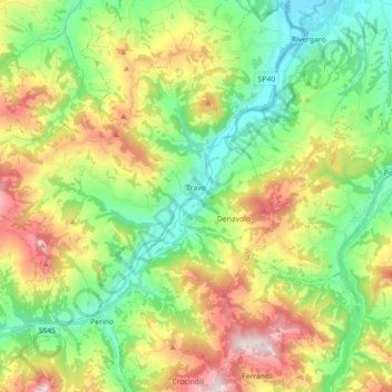
Name: Travo topographic map, elevation, terrain.

Location: Travo, Piacenza, Emilia-Romagna, Italy (44.79669 9.44966 44.92253 9.58841)

Average elevation: 1,276 ft

Minimum elevation: 400 ft

Maximum elevation: 2,785 ft

Other topographic maps

Click on a map to view its topography, its elevation and its terrain.

Misano

Italy > Emilia-Romagna > Piacenza > Agazzano

Average elevation: 787 ft

Crocinito

Italy > Emilia-Romagna > Piacenza

Average elevation: 1,854 ft

Bogli

Italy > Emilia-Romagna > Piacenza > Ottone

Average elevation: 3,898 ft

Sariano

Italy > Emilia-Romagna > Piacenza > Gropparello

Average elevation: 873 ft

Fiorano

Italy > Emilia-Romagna > Piacenza > Travo

Average elevation: 932 ft

Capannette di Pej

Italy > Emilia-Romagna > Piacenza > Zerba

Average elevation: 4,304 ft

Dadomo

Italy > Emilia-Romagna > Piacenza > Vernasca

Average elevation: 2,264 ft

Gear up for your next adventure:

🪶Paracord Bracelet - Survival bracelet with built‑in tools
🔦Powerful Headlamps - Ultra-bright hands-free lighting for night navigation
GPS Sports Watch - GPS watch for running, hiking and training
🗺️NatGeo Topo Maps - High-quality waterproof printed topographic maps of US Parks
❄️Traction Cleats - Prevent slips on icy trails during winter hikes

As an Amazon Associate, this site earns from qualifying purchases at no extra cost to you.