Geolocate

Springville topographic map

Click on the map to display elevation.

About this map

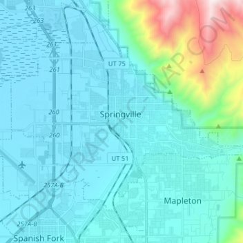
Name: Springville topographic map, elevation, terrain.

Location: Springville, Utah County, Utah, 84663, United States (40.13000 -111.67426 40.19416 -111.54575)

Average elevation: 5,138 ft

Minimum elevation: 4,478 ft

Maximum elevation: 9,619 ft

Utah County trails, hiking, mountain biking, running and outdoor activities

Other topographic maps

Click on a map to view its topography, its elevation and its terrain.

Spanish Fork Peak

United States > Utah > Utah County

Average elevation: 8,924 ft

Edgemont

United States > Utah > Utah County > Provo

Average elevation: 5,046 ft

Lone Peak

United States > Utah > Utah County

Average elevation: 9,885 ft

Mount Timpanogos

United States > Utah > Utah County

Average elevation: 10,299 ft

Bald Mountain Overlook

United States > Utah > Utah County

Average elevation: 8,373 ft

Mount Nebo

United States > Utah > Utah County

Average elevation: 10,220 ft

Mount Timpanogos

United States > Utah > Utah County

Average elevation: 10,299 ft

Nutty Putty Cave

United States > Utah > Utah County

Average elevation: 5,075 ft

Mount Timpanogos

United States > Utah > Utah County

Average elevation: 10,299 ft

Curtis

United States > Utah > Utah County > Orem

Average elevation: 4,701 ft

Caryhurst

United States > Utah > Utah County > Provo

Average elevation: 5,128 ft

Lone Peak

United States > Utah > Utah County

Average elevation: 9,885 ft

Birdseye

United States > Utah > Utah County

Average elevation: 5,840 ft

Pleasant View

United States > Utah > Utah County > Provo

Average elevation: 4,744 ft

Townsend

United States > Utah > Utah County > Genola

Average elevation: 4,718 ft

Gear up for your next adventure:

🪓Survival Multi‑Tool - Versatile tool for camp and trail tasks
🗃️Trail First Aid Kit - Essential kit for outdoor injuries and emergencies
📷Action Camera - Capture your outdoor adventures in HD
🧢Outdoor Hiking Hat - Sun protection hat for outdoor explorers
Backpacking Tents - Weight-optimized shelters for multi-day topographic surveys

As an Amazon Associate, this site earns from qualifying purchases at no extra cost to you.