
Make a donation
Gear up for your next adventure:
As an Amazon Associate, this site earns from qualifying purchases at no extra cost to you.
Curepto topographic map
Click on the map to display elevation.
Make a donation
Gear up for your next adventure:
As an Amazon Associate, this site earns from qualifying purchases at no extra cost to you.
About this map
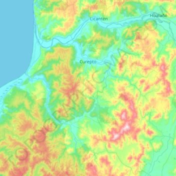
Name: Curepto topographic map, elevation, terrain.
Average elevation: 686 ft
Minimum elevation: -7 ft
Maximum elevation: 2,726 ft
Make a donation
Gear up for your next adventure:
As an Amazon Associate, this site earns from qualifying purchases at no extra cost to you.
Other topographic maps
Click on a map to view its topography, its elevation and its terrain.
Make a donation
Gear up for your next adventure:
As an Amazon Associate, this site earns from qualifying purchases at no extra cost to you.
Cerro del Medio
Chile > Región del Maule > Provincia de Talca > San Clemente
Las dimensiones de la caldera son 26 kilómetros por 14 kilómetros, y tiene una elevación de 3.508 metros. La actividad de la caldera ha producido muchos otros estratovolcanes para formar un volcán complejo.
Average elevation: 10,600 ft
Las Pitras
Chile > Región del Maule > Provincia de Talca > Constitución > San Ramón
Average elevation: 1,263 ft
Los Cristales - La Patagua
Chile > Región del Maule > Provincia de Talca > Pencahue
Average elevation: 659 ft
Make a donation
Gear up for your next adventure:
As an Amazon Associate, this site earns from qualifying purchases at no extra cost to you.
Las Corrientes
Chile > Región del Maule > Provincia de Talca > Constitución
Average elevation: 1,014 ft
Santa Clara Sur
Chile > Región del Maule > Provincia de Talca > Maule > Población Don Sebastian
Average elevation: 463 ft
Make a donation
Gear up for your next adventure:
As an Amazon Associate, this site earns from qualifying purchases at no extra cost to you.
Armerillo Poniente
Chile > Región del Maule > Provincia de Talca > San Clemente
Average elevation: 2,523 ft
Make a donation
Gear up for your next adventure:
As an Amazon Associate, this site earns from qualifying purchases at no extra cost to you.
Salto La Leona
Chile > Región del Maule > Provincia de Talca > San Clemente
Average elevation: 3,566 ft
Make a donation
Gear up for your next adventure:
As an Amazon Associate, this site earns from qualifying purchases at no extra cost to you.
Vilches Centro
Chile > Región del Maule > Provincia de Talca > San Clemente
Average elevation: 1,880 ft
Make a donation
Gear up for your next adventure:
As an Amazon Associate, this site earns from qualifying purchases at no extra cost to you.
Bramadero
Chile > Región del Maule > Provincia de Talca > San Clemente > Bramadero
Average elevation: 1,289 ft
Quiñipeumo Oriente
Chile > Región del Maule > Provincia de Talca > Maule > Pedro Nolasco > Quiñipeumo Oriente
Average elevation: 440 ft
Mariposas
Chile > Región del Maule > Provincia de Talca > San Clemente > Mariposas
Average elevation: 794 ft
Camarico
Chile > Región del Maule > Provincia de Talca > Río Claro > Camarico
Average elevation: 630 ft
Make a donation
Gear up for your next adventure:
As an Amazon Associate, this site earns from qualifying purchases at no extra cost to you.
Coipué
Chile > Región del Maule > Provincia de Talca > Constitución > Coipué
Average elevation: 325 ft
Cerro La Campana
Chile > Región del Maule > Provincia de Talca > San Clemente
Average elevation: 3,189 ft
Make a donation
Gear up for your next adventure:
As an Amazon Associate, this site earns from qualifying purchases at no extra cost to you.