
Make a donation
Gear up for your next adventure:
As an Amazon Associate, this site earns from qualifying purchases at no extra cost to you.
Vedder River topographic map
Click on the map to display elevation.
Make a donation
Gear up for your next adventure:
As an Amazon Associate, this site earns from qualifying purchases at no extra cost to you.
About this map
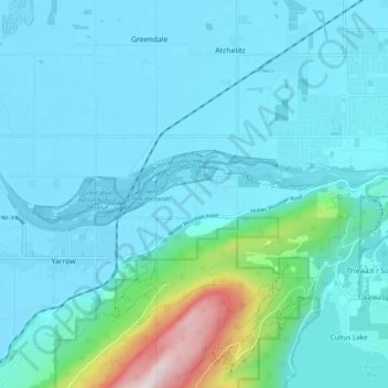
Name: Vedder River topographic map, elevation, terrain.
Average elevation: 361 ft
Minimum elevation: 7 ft
Maximum elevation: 2,808 ft
Make a donation
Gear up for your next adventure:
As an Amazon Associate, this site earns from qualifying purchases at no extra cost to you.
Other topographic maps
Click on a map to view its topography, its elevation and its terrain.
Minto Landing
Canada > British Columbia > Fraser Valley Regional District > Chilliwack
Average elevation: 62 ft
Vedder Mountain
Canada > British Columbia > Fraser Valley Regional District > Chilliwack
Average elevation: 1,824 ft
Rosedale
Canada > British Columbia > Fraser Valley Regional District > Chilliwack
Average elevation: 75 ft
Elk Mountain
Canada > British Columbia > Fraser Valley Regional District > Chilliwack
Average elevation: 3,310 ft
Make a donation
Gear up for your next adventure:
As an Amazon Associate, this site earns from qualifying purchases at no extra cost to you.