
Make a donation
Gear up for your next adventure:
As an Amazon Associate, this site earns from qualifying purchases at no extra cost to you.
Goshen topographic map
Click on the map to display elevation.
Make a donation
Gear up for your next adventure:
As an Amazon Associate, this site earns from qualifying purchases at no extra cost to you.
About this map
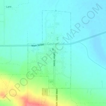
Name: Goshen topographic map, elevation, terrain.
Location: Goshen, Utah County, Utah, 84633, United States (39.93980 -111.90917 39.96152 -111.89480)
Average elevation: 4,570 ft
Minimum elevation: 4,518 ft
Maximum elevation: 4,747 ft
Utah County trails, hiking, mountain biking, running and outdoor activities
Make a donation
Gear up for your next adventure:
As an Amazon Associate, this site earns from qualifying purchases at no extra cost to you.
Other topographic maps
Click on a map to view its topography, its elevation and its terrain.
Make a donation
Gear up for your next adventure:
As an Amazon Associate, this site earns from qualifying purchases at no extra cost to you.
Saratoga Springs Park
United States > Utah > Utah County > Saratoga Springs > Saratoga Resort
Average elevation: 4,511 ft
Make a donation
Gear up for your next adventure:
As an Amazon Associate, this site earns from qualifying purchases at no extra cost to you.