Geolocate

Dunlap topographic map

Click on the map to display elevation.

About this map

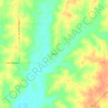
Name: Dunlap topographic map, elevation, terrain.

Location: Dunlap, Grundy County, Missouri, United States (40.08835 -93.50244 40.12835 -93.46244)

Average elevation: 856 ft

Minimum elevation: 787 ft

Maximum elevation: 928 ft

Grundy County trails, hiking, mountain biking, running and outdoor activities

Other topographic maps

Click on a map to view its topography, its elevation and its terrain.

Galt

United States > Missouri > Grundy County

Average elevation: 830 ft

Laredo

United States > Missouri > Grundy County

Average elevation: 801 ft

Tindall

United States > Missouri > Grundy County

Average elevation: 814 ft

Brimson

United States > Missouri > Grundy County

Average elevation: 797 ft

Gear up for your next adventure:

🎒Trail Energy Bars - High‑calorie bars for hiking energy
🔥Plasma Lighters - Windproof lighters that work in any weather condition
👖Convertible Hiking Pants - Versatile zip-off pants for changing altitudes and temperatures
🎒Waterproof Dry Bags - Keep your electronics and maps dry inside your pack
🌄Hiking Binoculars - Compact binoculars for scenic views and trail spotting

As an Amazon Associate, this site earns from qualifying purchases at no extra cost to you.