Geolocate

Hamilton topographic map

Click on the map to display elevation.

About this map

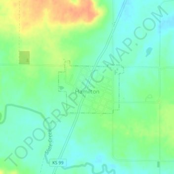
Name: Hamilton topographic map, elevation, terrain.

Location: Hamilton, Greenwood County, Kansas, 66853, United States (37.97660 -96.17027 37.98477 -96.15744)

Average elevation: 1,109 ft

Minimum elevation: 1,060 ft

Maximum elevation: 1,188 ft

Greenwood County trails, hiking, mountain biking, running and outdoor activities

Other topographic maps

Click on a map to view its topography, its elevation and its terrain.

Neal

United States > Kansas > Greenwood County

Average elevation: 1,001 ft

Piedmont

United States > Kansas > Greenwood County

Average elevation: 1,230 ft

Quincy

United States > Kansas > Greenwood County > Quincy

Average elevation: 965 ft

Gear up for your next adventure:

🛰️Satellite Messengers - Emergency SOS and two-way messaging for off-grid adventures
🦟Ultrasonic Repellers - Create a bug-free zone at your camp or rest stop
🎒Day Hiking Backpack - Lightweight backpack perfect for day trips and outdoor adventures
📶Vehicle Signal Boosters - Improve reception in rural areas while driving to trailheads
🥾Women's Hiking Boots - Top-rated trail boots with ankle support and superior grip

As an Amazon Associate, this site earns from qualifying purchases at no extra cost to you.