
Make a donation
Gear up for your next adventure:
As an Amazon Associate, this site earns from qualifying purchases at no extra cost to you.
Miranjani topographic map
Click on the map to display elevation.
Make a donation
Gear up for your next adventure:
As an Amazon Associate, this site earns from qualifying purchases at no extra cost to you.
Miranjani
Miranjani is the highest peak in Galyat Region which is located at the elevation of 2,992 metres (9,816 ft), in Abbottabad District of Khyber Pakhtunkhwa the Province of Pakistan. It is located in the Namli Maira area, in Ayubia National Park, 80 kilometres (50 mi) north of Islamabad in the western Himalayan range.
Make a donation
Gear up for your next adventure:
As an Amazon Associate, this site earns from qualifying purchases at no extra cost to you.
About this map
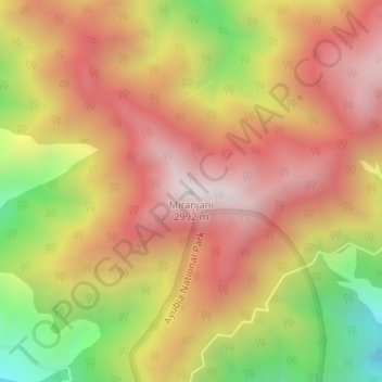
Name: Miranjani topographic map, elevation, terrain.
Location: Miranjani, Khyber Pakhtunkhwa, Pakistan (34.10504 73.40718 34.10514 73.40728)
Average elevation: 8,350 ft
Minimum elevation: 6,427 ft
Maximum elevation: 9,708 ft
Make a donation
Gear up for your next adventure:
As an Amazon Associate, this site earns from qualifying purchases at no extra cost to you.
Other topographic maps
Click on a map to view its topography, its elevation and its terrain.
Torghar District
Machai Sar or Machai Peak is the highest peak of Torghar mountain at an altitude of 9,755 feet from the Mean sea level. Machai Sar Meadows is located northwest of Oghi Town of Mansehra District, near Machai Dhanda or Danda. The conference was less popular because it was located in the remote area of Mansehra…
Average elevation: 4,334 ft
Kurram River
Generally, the topography of the catchment area of the Kurrama River is mountainous in the upper reaches near Ali Khayl, Mirazi Kalay, Peer Kalai, Kharlachi, Parachinar and Thal areas. Near Bannu city, the river flattens up and follows a consistent mild slope up to its outfall in to the Indus River near Isa…
Average elevation: 1,430 ft
Make a donation
Gear up for your next adventure:
As an Amazon Associate, this site earns from qualifying purchases at no extra cost to you.
Swat District
The average elevation of Swat is 980 m (3,220 ft), resulting in a considerably cooler and wetter climate compared to the rest of Pakistan. With lush forests, verdant alpine meadows, and snow-capped mountains, Swat is one of the country's most popular tourist destinations.
Average elevation: 8,773 ft
Gantar Khwar
Pakistan > Khyber Pakhtunkhwa > Battagram District > Allai Tehsil > Palang
Average elevation: 6,831 ft
Make a donation
Gear up for your next adventure:
As an Amazon Associate, this site earns from qualifying purchases at no extra cost to you.
Kalam Tehsil
At an elevation about 2,000 m (6,600 ft) above sea level, the valley itself provides a plateau that is located above the river and is used for farming. There are a number of visible mountains, also visible from Matiltan, a valley close to Kalam Valley, including Mount Falaksar 5,918 meters (19,416 feet), and…
Average elevation: 12,861 ft
Lower Chitral District
Pakistan > Khyber Pakhtunkhwa > Former Chitrāl District
Average elevation: 12,090 ft
North Waziristan District
Pakistan > Khyber Pakhtunkhwa > North Waziristan District
Average elevation: 4,820 ft
Former Chitrāl District
Pakistan > Khyber Pakhtunkhwa > Former Chitrāl District
Chitral is connected to the rest of Pakistan by two major road routes, the Lowari Pass (el. 10,230 ft.) from Dir and Shandur Top (elevation 12,200 ft.) from Gilgit. Both routes used to be closed in winter, but circa 2017 the highway Lowari Tunnel under the Lowari Pass opened to vehicular traffic for at least…
Average elevation: 12,234 ft
Make a donation
Gear up for your next adventure:
As an Amazon Associate, this site earns from qualifying purchases at no extra cost to you.
Lakki Marwat
Pakistan > Khyber Pakhtunkhwa > Lakki Marwat
The district is a combination of hills and sandy plains. The hilly areas are along the boundaries of the district especially in the east, southeast, southwest and northwest. In the southeast, the Marwat range separates Lakki Marwat from Dera Ismail Khan District while in the east the Karak Niazi range…
Average elevation: 1,132 ft