
Make a donation
Gear up for your next adventure:
As an Amazon Associate, this site earns from qualifying purchases at no extra cost to you.
Swat District topographic map
Click on the map to display elevation.
Make a donation
Gear up for your next adventure:
As an Amazon Associate, this site earns from qualifying purchases at no extra cost to you.
Swat District
The average elevation of Swat is 980 m (3,220 ft), resulting in a considerably cooler and wetter climate compared to the rest of Pakistan. With lush forests, verdant alpine meadows, and snow-capped mountains, Swat is one of the country's most popular tourist destinations.
Make a donation
Gear up for your next adventure:
As an Amazon Associate, this site earns from qualifying purchases at no extra cost to you.
About this map
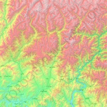
Name: Swat District topographic map, elevation, terrain.
Location: Swat District, Malakand Division, Khyber Pakhtunkhwa, Pakistan (34.56772 72.09932 35.89610 72.81086)
Average elevation: 8,773 ft
Minimum elevation: 1,529 ft
Maximum elevation: 19,652 ft
Make a donation
Gear up for your next adventure:
As an Amazon Associate, this site earns from qualifying purchases at no extra cost to you.
Other topographic maps
Click on a map to view its topography, its elevation and its terrain.
Make a donation
Gear up for your next adventure:
As an Amazon Associate, this site earns from qualifying purchases at no extra cost to you.
Kurram River
Generally, the topography of the catchment area of the Kurrama River is mountainous in the upper reaches near Ali Khayl, Mirazi Kalay, Peer Kalai, Kharlachi, Parachinar and Thal areas. Near Bannu city, the river flattens up and follows a consistent mild slope up to its outfall in to the Indus River near Isa…
Average elevation: 1,430 ft
Mastuj
Pakistan > Khyber Pakhtunkhwa > Chitrāl District
Mastuj (Urdu: مستوج) is a town and Tehsil of Upper Chitral District in Khyber-Pakhtunkhwa province of Pakistan. It is located at 36°17'0N 72°31'0E with an altitude of 2359 metres (7742 feet). There are ruins of old fort built originally in 18th century and reconstructed several times.
Average elevation: 10,036 ft
Make a donation
Gear up for your next adventure:
As an Amazon Associate, this site earns from qualifying purchases at no extra cost to you.
Zarobi
Pakistan > Khyber Pakhtunkhwa > Swabi District
Zarobai Munara, commonly known as Zarobi, is a historical village and Union Council of Swabi District in the Khyber Pakhtunkhwa province of Pakistan. It is located at 34°2′0N 72°34′0E with an altitude of 321 metres (1056 feet).
Average elevation: 1,063 ft
Make a donation
Gear up for your next adventure:
As an Amazon Associate, this site earns from qualifying purchases at no extra cost to you.
University Town
Pakistan > Khyber Pakhtunkhwa > Peshāwar District > Peshawar City Tehsil
Average elevation: 1,217 ft
Gantar Khwar
Pakistan > Khyber Pakhtunkhwa > Battagram District > Allai Tehsil > Palang
Average elevation: 6,831 ft
Make a donation
Gear up for your next adventure:
As an Amazon Associate, this site earns from qualifying purchases at no extra cost to you.
Regi Aftizai
Pakistan > Khyber Pakhtunkhwa > Peshāwar District > Peshawar City Tehsil
Average elevation: 1,158 ft
Make a donation
Gear up for your next adventure:
As an Amazon Associate, this site earns from qualifying purchases at no extra cost to you.
Miranjani
Miranjani is the highest peak in Galyat Region which is located at the elevation of 2,992 metres (9,816 ft), in Abbottabad District of Khyber Pakhtunkhwa the Province of Pakistan. It is located in the Namli Maira area, in Ayubia National Park, 80 kilometres (50 mi) north of Islamabad in the western Himalayan…
Average elevation: 8,350 ft
Make a donation
Gear up for your next adventure:
As an Amazon Associate, this site earns from qualifying purchases at no extra cost to you.
Make a donation
Gear up for your next adventure:
As an Amazon Associate, this site earns from qualifying purchases at no extra cost to you.
Sadiq Naqar Syed Khan Banda
Pakistan > Khyber Pakhtunkhwa > Naqar Syed Khan Banda > Sadiq Naqar Syed Khan Banda
Average elevation: 1,230 ft
Drosh
Pakistan > Khyber Pakhtunkhwa > Former Chitrāl District > Drosh
Khowar and Pashto languages are the language spoken by the majority of the people in Drosh. As Drosh is low elevation and is the large village in Chitral District on the traditional trade route to Drosh-Jalalabad road.
Average elevation: 6,073 ft
Make a donation
Gear up for your next adventure:
As an Amazon Associate, this site earns from qualifying purchases at no extra cost to you.
Make a donation
Gear up for your next adventure:
As an Amazon Associate, this site earns from qualifying purchases at no extra cost to you.