
Milan topographic map
Interactive map
Click on the map to display elevation.
About this map
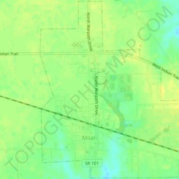
Name: Milan topographic map, elevation, terrain.
Location: Milan, Ripley County, Indiana, United States (39.11512 -85.14099 39.14180 -85.11063)
Average elevation: 997 ft
Minimum elevation: 958 ft
Maximum elevation: 1,024 ft
Other topographic maps
Click on a map to view its topography, its elevation and its terrain.
Versailles
United States > Indiana > Ripley County
Versailles, Ripley County, Indiana, United States
Average elevation: 938 ft
Osgood
United States > Indiana > Ripley County
Osgood, Ripley County, Indiana, United States
Average elevation: 984 ft
Batesville
United States > Indiana > Ripley County
Batesville, Ripley County, Indiana, 47006, United States
Average elevation: 965 ft
Prattsburg
United States > Indiana > Ripley County
Prattsburg, Ripley County, Indiana, United States
Average elevation: 978 ft
Delaware
United States > Indiana > Ripley County
Delaware, Ripley County, Indiana, United States
Average elevation: 971 ft