
Make a donation
Gear up for your next adventure:
As an Amazon Associate, this site earns from qualifying purchases at no extra cost to you.
Howard Lake topographic map
Click on the map to display elevation.
Make a donation
Gear up for your next adventure:
As an Amazon Associate, this site earns from qualifying purchases at no extra cost to you.
About this map
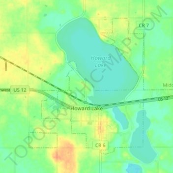
Name: Howard Lake topographic map, elevation, terrain.
Location: Howard Lake, Wright County, Minnesota, 55349, United States (45.04924 -94.09387 45.08334 -94.03255)
Average elevation: 1,024 ft
Minimum elevation: 978 ft
Maximum elevation: 1,086 ft
Wright County trails, hiking, mountain biking, running and outdoor activities
Make a donation
Gear up for your next adventure:
As an Amazon Associate, this site earns from qualifying purchases at no extra cost to you.
Other topographic maps
Click on a map to view its topography, its elevation and its terrain.
South Haven
United States > Minnesota > Wright County > South Haven > South Haven
Average elevation: 1,086 ft
Annandale
United States > Minnesota > Wright County > Annandale > Annandale
Average elevation: 1,063 ft
Make a donation
Gear up for your next adventure:
As an Amazon Associate, this site earns from qualifying purchases at no extra cost to you.
Maple Lake
United States > Minnesota > Wright County > Maple Lake > Maple Lake
Average elevation: 1,030 ft