
Bull Shoals topographic map
Interactive map
Click on the map to display elevation.
About this map
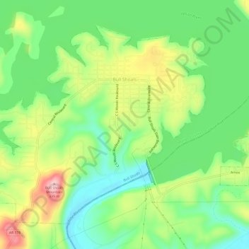
Name: Bull Shoals topographic map, elevation, terrain.
Location: Bull Shoals, Marion County, Arkansas, 72619, United States (36.35589 -92.62154 36.39442 -92.56161)
Average elevation: 692 ft
Minimum elevation: 440 ft
Maximum elevation: 1,096 ft
Other topographic maps
Click on a map to view its topography, its elevation and its terrain.
Yellville
United States > Arkansas > Marion County
Yellville, Marion County, Arkansas, 72687, United States
Average elevation: 692 ft
Flippin
United States > Arkansas > Marion County
Flippin, Marion County, Arkansas, 72634, United States
Average elevation: 679 ft
Peel
United States > Arkansas > Marion County
Peel, Marion County, Arkansas, 72668, United States
Average elevation: 801 ft
Bull Shoals
United States > Arkansas > Marion County > Bull Shoals
Bull Shoals, Marion County, Arkansas, 72619, United States
Average elevation: 692 ft
Pyatt
United States > Arkansas > Marion County > Pyatt
Pyatt, Marion County, Arkansas, 72672, United States
Average elevation: 853 ft
Oakland
United States > Arkansas > Marion County
Oakland, Marion County, Arkansas, 72661, United States
Average elevation: 850 ft