
Hiawatha topographic map
Interactive map
Click on the map to display elevation.
About this map
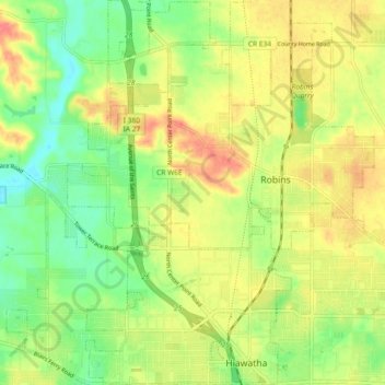
Name: Hiawatha topographic map, elevation, terrain.
Location: Hiawatha, Linn County, Iowa, 52233, United States (42.03467 -91.71640 42.10266 -91.66302)
Average elevation: 840 ft
Minimum elevation: 741 ft
Maximum elevation: 945 ft
The elevation of Hiawatha is 850 feet (260 m) above sea level.[2]
Other topographic maps
Click on a map to view its topography, its elevation and its terrain.
Cedar Rapids
United States > Iowa > Linn County
Cedar Rapids, Linn County, Iowa, United States
Average elevation: 804 ft
Bertram
United States > Iowa > Linn County
Bertram, Linn County, Iowa, United States
Average elevation: 761 ft
Toddville
United States > Iowa > Linn County
Toddville, Linn County, Iowa, 52341, United States
Average elevation: 833 ft
Marion
United States > Iowa > Linn County
Marion, Linn County, Iowa, 52302, United States
Average elevation: 840 ft
Cedar Rapids
United States > Iowa > Linn County > Cedar Rapids
Cedar Rapids, Linn County, Iowa, 52401, United States
Average elevation: 817 ft
Bertram
United States > Iowa > Linn County > Bertram > Bertram
Bertram, Linn County, Iowa, United States
Average elevation: 758 ft
Central City
United States > Iowa > Linn County > Central City
Central City, Linn County, Iowa, 52214, United States
Average elevation: 883 ft
Robins
United States > Iowa > Linn County > Robins
Robins, Linn County, Iowa, 52328, United States
Average elevation: 860 ft
Palo
United States > Iowa > Linn County > Palo
Palo, Linn County, Iowa, United States
Average elevation: 751 ft
Central City
United States > Iowa > Linn County
Central City, Linn County, Iowa, United States
Average elevation: 869 ft
Springville
United States > Iowa > Linn County
Springville, Linn County, Iowa, 52336, United States
Average elevation: 869 ft
Mount Vernon
United States > Iowa > Linn County > Mount Vernon
Mount Vernon, Linn County, Iowa, 52314, United States
Average elevation: 833 ft