
West Tisbury topographic map
Interactive map
Click on the map to display elevation.
About this map
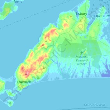
Name: West Tisbury topographic map, elevation, terrain.
Average elevation: 23 ft
Minimum elevation: -69 ft
Maximum elevation: 279 ft
Dukes County trails, hiking, mountain biking, running and outdoor activities
Other topographic maps
Click on a map to view its topography, its elevation and its terrain.
Southern Woodlands Reservation
United States > Massachusetts > Dukes County > Oak Bluffs
Average elevation: 56 ft
North Tisbury
United States > Massachusetts > Dukes County > West Tisbury > North Tisbury
Average elevation: 79 ft