
Groton topographic map
Interactive map
Click on the map to display elevation.
About this map
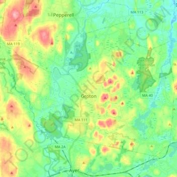
Name: Groton topographic map, elevation, terrain.
Average elevation: 279 ft
Minimum elevation: 151 ft
Maximum elevation: 535 ft
Middlesex County trails, hiking, mountain biking, running and outdoor activities
Other topographic maps
Click on a map to view its topography, its elevation and its terrain.
Freeman Lake
United States > Massachusetts > Middlesex County > Chelmsford > North Chelmsford
Average elevation: 131 ft
Newton
United States > Massachusetts > Middlesex County > Newton
Newton has grown around a formation of seven hills. "The general features of Newton are not without interest. Seven principal elevations mark its surface, like the seven hills of ancient Rome, with the difference that the seven hills of Newton are much more distinct than the seven hills of Rome: Nonantum Hill,…
Average elevation: 141 ft
Musketamquid Village
United States > Massachusetts > Middlesex County > Sudbury
Average elevation: 190 ft
Waitts Mount
United States > Massachusetts > Middlesex County > Malden > Malden Centre
Average elevation: 72 ft
Reading Highlands
United States > Massachusetts > Middlesex County > Reading
Average elevation: 112 ft
Liberty Heights
United States > Massachusetts > Middlesex County > Lexington
Average elevation: 230 ft
Lake Mascuppic
United States > Massachusetts > Middlesex County > Tyngsborough > Willowdale
Average elevation: 187 ft
Horn Pond Mountain
United States > Massachusetts > Middlesex County > Woburn
Average elevation: 108 ft
Arlington Heights
United States > Massachusetts > Middlesex County > Arlington
Average elevation: 190 ft
Framingham Center
United States > Massachusetts > Middlesex County > Framingham
Average elevation: 190 ft
Lowell
United States > Massachusetts > Middlesex County > Lowell
Lowell is located at the confluence of the Merrimack and Concord rivers. The Pawtucket Falls, a mile-long set of rapids with a total drop in elevation of 32 feet, ends where the two rivers meet. At the top of the falls is the Pawtucket Dam, designed to turn the upper Merrimack into a millpond, diverted through…
Average elevation: 180 ft
North Wilmington
United States > Massachusetts > Middlesex County > Wilmington
Average elevation: 95 ft
North Lexington
United States > Massachusetts > Middlesex County > Lexington
Average elevation: 197 ft
Memorial Beach
United States > Massachusetts > Middlesex County > Marlborough
Average elevation: 315 ft
Maynard
United States > Massachusetts > Middlesex County
According to the United States Census Bureau, Maynard has a total area of 5.4 square miles (13.9 km2), of which 5.2 square miles (13.6 km2) is land and 0.1 square miles (0.3 km2), or 2.42%, is water. Average elevation is roughly 200 feet (~61 m) above sea level; the highest point is Summer Hill, elevation 358…
Average elevation: 210 ft
Glendale
United States > Massachusetts > Middlesex County > Everett > Glendale
Average elevation: 46 ft
Boxboro
United States > Massachusetts > Middlesex County > Boxborough > Boxboro
Average elevation: 325 ft
Doeskin Hills
United States > Massachusetts > Middlesex County > Framingham > Doeskin Hills
Average elevation: 289 ft
Baker Bridge
United States > Massachusetts > Middlesex County > Lincoln > Baker Bridge
Average elevation: 203 ft
West Village
United States > Massachusetts > Middlesex County > Marlborough > West Village
Average elevation: 377 ft