
Agordo topographic map
Interactive map
Click on the map to display elevation.
About this map
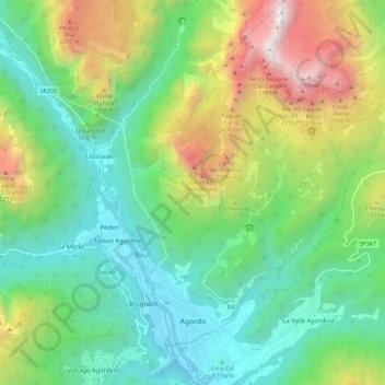
Name: Agordo topographic map, elevation, terrain.
Location: Agordo, Belluno, Veneto, 32021, Italy (46.26885 11.99339 46.34841 12.08205)
Average elevation: 4,239 ft
Minimum elevation: 1,847 ft
Maximum elevation: 9,327 ft
Other topographic maps
Click on a map to view its topography, its elevation and its terrain.
Zwölferkofel - Croda dei Toni
Italy > Veneto > Belluno > Auronzo di Cadore
Average elevation: 7,766 ft
Pieve di Cadore
Italy > Veneto > Belluno > Pieve di Cadore > Pieve di Cadore
Average elevation: 3,661 ft
Gruppo del Pomagagnon
Italy > Veneto > Belluno > Cortina d'Ampezzo
Pomagagnon is a mountain of the Dolomites in Belluno, northern Italy. It has an elevation of 2,450 metres (8,038 ft) and is the southernmost mountain of the Cristallo Group, towering 1,200 metres (3,937 ft) over the resort of Cortina d'Ampezzo. The mountain is part of the "Natural Park of the Ampezzo…
Average elevation: 5,768 ft