
Dali City topographic map
Interactive map
Click on the map to display elevation.
About this map
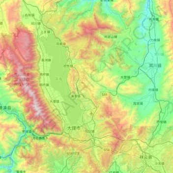
Name: Dali City topographic map, elevation, terrain.
Location: Dali City, Dali, Yunnan, China (25.42669 99.97900 26.07919 100.43773)
Average elevation: 7,339 ft
Minimum elevation: 4,288 ft
Maximum elevation: 13,327 ft
Other topographic maps
Click on a map to view its topography, its elevation and its terrain.
Shangri-La
China > Yunnan > Shangri-La > Jiantang
Shangri-La has either a dry-winter, warm-summer humid continental climate (Köppen climate classification: Dwb), or a dry-winter subtropical highland climate (Köppen climate classification: Cwb), both of which are unusually cool by Yunnan standards due to the high elevation, which ranges between 2,700 and…
Average elevation: 12,054 ft
Pingbian
China > Yunnan > Pingbian Miao Autonomous County
Pingbian County has a mild subtropical highland climate (Köppen Cwb) influenced by its elevation, with short, mild, dry winters and warm, humid summers. The monthly 24-hour average temperature ranges from 9.2 °C (48.6 °F) in January to 21.3 °C (70.3 °F) in July, and the annual mean is 16.3 °C (61.3 °F).…
Average elevation: 3,829 ft
Wenshan Zhuang and Miao Autonomous Prefecture
China > Yunnan > Wenshan Zhuang and Miao Autonomous Prefecture > Xizhang
Average elevation: 4,039 ft
Tengchong
Situated at the southwestern end of the (transversely faulted) Hengduan Mountains, Tengchong topographically assumes the form of a horseshoe with the opening facing the south. The easternmost sources of the Irrawaddy River issue from the high mountains at the summit of Mount Danaozi of Gaoligong Mountain,…
Average elevation: 5,807 ft