
Independence Charter Township topographic map
Click on the map to display elevation.
Independence Charter Township
Independence Township is located along the Hillsdale-Lapeer Moraine Range. The highest hill along that range in Independence Township is Pine Knob, at 1,221 feet. It is also the highest point in Southeastern Michigan. Only three miles away is Waterford Hill, the second highest hill in Independence Township with an elevation of 1,150 feet. Atop Waterford Hill is Olympus Circle, the highest elevation of any residential street in Independence Township.
About this map
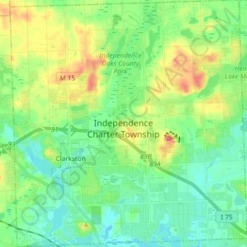
Name: Independence Charter Township topographic map, elevation, terrain.
Average elevation: 1,043 ft
Minimum elevation: 945 ft
Maximum elevation: 1,263 ft
Oakland County trails, hiking, mountain biking, running and outdoor activities
Other topographic maps
Click on a map to view its topography, its elevation and its terrain.
Kensington Metropark
United States > Michigan > Oakland County > Milford Charter Township
Average elevation: 974 ft
New Hudson
United States > Michigan > Oakland County > Lyon Charter Township
Average elevation: 951 ft
Clyde
United States > Michigan > Oakland County > Highland Charter Township
Average elevation: 1,033 ft
Oxbow
United States > Michigan > Oakland County > White Lake Charter Township
Average elevation: 961 ft
Union Lake
United States > Michigan > Oakland County > White Lake Charter Township
Average elevation: 951 ft
Jossman Acres
United States > Michigan > Oakland County > Springfield Charter Township
Average elevation: 1,063 ft
Oxbow
United States > Michigan > Oakland County > White Lake Charter Township
Average elevation: 961 ft
Cranberry Lake
United States > Michigan > Oakland County > White Lake Charter Township
Average elevation: 968 ft
North Farmington
United States > Michigan > Oakland County > Farmington Hills
Average elevation: 909 ft
Carpenter Lake Nature Preserve
United States > Michigan > Oakland County > Southfield
Average elevation: 679 ft
Dollar Lake
United States > Michigan > Oakland County > Independence Charter Township
Average elevation: 1,004 ft
Davisburg
United States > Michigan > Oakland County > Springfield Charter Township
Average elevation: 1,014 ft
Huron Heights
United States > Michigan > Oakland County > Waterford Charter Township
Average elevation: 958 ft
Rochester Hills
United States > Michigan > Oakland County > Rochester Hills
Rochester Hills is bordered to the north by Oakland Charter Township along Dutton Road, to the south by the city of Troy along South Boulevard, to the east by Shelby Township in Macomb County along Dequindre Road, and to the west by the city of Auburn Hills along part of Adams Road. Rochester Hills is also…
Average elevation: 807 ft