Geolocate

Leech Lake topographic map

Click on the map to display elevation.

About this map

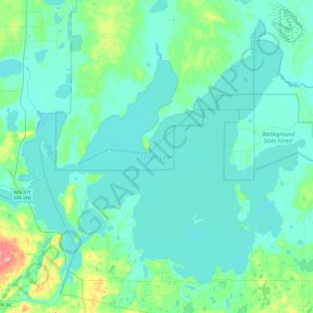
Name: Leech Lake topographic map, elevation, terrain.

Location: Leech Lake, Cass County, Minnesota, 56484, United States (47.03897 -94.67232 47.31520 -94.20991)

Average elevation: 1,325 ft

Minimum elevation: 1,280 ft

Maximum elevation: 1,631 ft

Cass County trails, hiking, mountain biking, running and outdoor activities

Other topographic maps

Click on a map to view its topography, its elevation and its terrain.

Corset Lake

United States > Minnesota > Cass County

Average elevation: 1,335 ft

Snowshoe Lake

United States > Minnesota > Cass County

Average elevation: 1,332 ft

Big Deep Lake

United States > Minnesota > Cass County

Average elevation: 1,378 ft

Kego Lake

United States > Minnesota > Cass County

Average elevation: 1,355 ft

Crooked Lake

United States > Minnesota > Cass County > Wabedo

Average elevation: 1,332 ft

Lake May

United States > Minnesota > Cass County > Walker

Average elevation: 1,375 ft

Hiram Lake

United States > Minnesota > Cass County

Average elevation: 1,381 ft

Whipholt

United States > Minnesota > Cass County

Average elevation: 1,322 ft

Gould Lake

United States > Minnesota > Cass County

Average elevation: 1,309 ft

Inguadona

United States > Minnesota > Cass County

Average elevation: 1,325 ft

High Bank Lake

United States > Minnesota > Cass County

Average elevation: 1,394 ft

Blind Lake

United States > Minnesota > Cass County

Average elevation: 1,381 ft

Gear up for your next adventure:

🗺️NatGeo Topo Maps - High-quality waterproof printed topographic maps of US Parks
🌲Outdoor Survival Books - Best books on survival skills
📶Satellite Messenger - Communication device off‑grid
🪶Paracord Bracelet - Survival bracelet with built‑in tools
🛠️Outdoor Gear Repair Kit - Essential tools to fix gear on the trail

As an Amazon Associate, this site earns from qualifying purchases at no extra cost to you.