
Cornelius topographic map
Interactive map
Click on the map to display elevation.
Cornelius
Cornelius is located along Lake Norman in northern Mecklenburg County. The town lies approximately 20 miles (30 km) north of Charlotte, at an elevation of 742 feet.
About this map
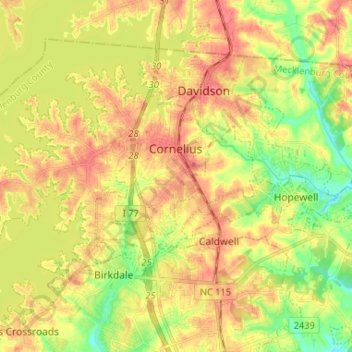
Name: Cornelius topographic map, elevation, terrain.
Location: Cornelius, Mecklenburg County, North Carolina, United States (35.43927 -80.94650 35.50733 -80.81601)
Average elevation: 761 ft
Minimum elevation: 653 ft
Maximum elevation: 850 ft
Mecklenburg County trails, hiking, mountain biking, running and outdoor activities
Other topographic maps
Click on a map to view its topography, its elevation and its terrain.
Idlewild Farms
United States > North Carolina > Mecklenburg County > Charlotte
Average elevation: 728 ft
Beverly Woods East
United States > North Carolina > Mecklenburg County > Charlotte
Average elevation: 666 ft
Coulwood Park
United States > North Carolina > Mecklenburg County > Charlotte > Coulwood Hills
Average elevation: 692 ft
Oakdale Forest
United States > North Carolina > Mecklenburg County > Charlotte
Average elevation: 745 ft
Mecklenburg County Sportsplex at Matthews
United States > North Carolina > Mecklenburg County > Matthews > Club View Acres
Average elevation: 738 ft
Mecklenberg Wildlife Club Lake
United States > North Carolina > Mecklenburg County > Charlotte
Average elevation: 702 ft
Olde Georgetowne
United States > North Carolina > Mecklenburg County > Charlotte
Average elevation: 636 ft
President James K. Polk State Historic Site
United States > North Carolina > Mecklenburg County > Pineville
Average elevation: 574 ft
North Mecklenburg Park
United States > North Carolina > Mecklenburg County > Huntersville
Average elevation: 781 ft
Deschutes Pond
United States > North Carolina > Mecklenburg County > Huntersville
Average elevation: 735 ft
Carmel Road Park
United States > North Carolina > Mecklenburg County > Charlotte > Carmel Woods
Average elevation: 650 ft
Hope Park
United States > North Carolina > Mecklenburg County > Charlotte > Hope Park
Average elevation: 764 ft
Country Roads
United States > North Carolina > Mecklenburg County > Charlotte > Country Roads
Average elevation: 653 ft