
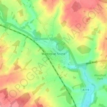
Watton-at-Stone topographic map
Interactive map
Click on the map to display elevation.
About this map
Name: Watton-at-Stone topographic map, elevation, terrain.
Average elevation: 282 ft
Minimum elevation: 151 ft
Maximum elevation: 417 ft
Other topographic maps
Click on a map to view its topography, its elevation and its terrain.
Astonbury Wood
United Kingdom > England > Hertfordshire > East Hertfordshire > Aston
Astonbury Wood, Aston, East Hertfordshire, Hertfordshire, England, United Kingdom
Average elevation: 272 ft
Stanstead St Margarets
United Kingdom > England > Hertfordshire > East Hertfordshire
Stanstead St Margarets, East Hertfordshire, Hertfordshire, England, SG12 8DH, United Kingdom
Average elevation: 157 ft
Burnham Green
United Kingdom > England > Hertfordshire > East Hertfordshire
Burnham Green, East Hertfordshire, Hertfordshire, England, AL6 0HA, United Kingdom
Average elevation: 335 ft
Furneux Pelham
United Kingdom > England > Hertfordshire > East Hertfordshire
Furneux Pelham, East Hertfordshire, Hertfordshire, England, United Kingdom
Average elevation: 371 ft
Chapmore End
United Kingdom > England > Hertfordshire > East Hertfordshire > Tonwell
Chapmore End, Bengeo Rural, Tonwell, East Hertfordshire, Hertfordshire, England, SG12 0HF, United Kingdom
Average elevation: 213 ft
King's Meads
United Kingdom > England > Hertfordshire > East Hertfordshire > Ware
King's Meads, Glaxo Footbridge, Kings Hill, Ware, East Hertfordshire, Hertfordshire, England, SG12 0GG, United Kingdom
Average elevation: 174 ft
Benington
United Kingdom > England > Hertfordshire > East Hertfordshire
Benington, East Hertfordshire, Hertfordshire, England, SG2 7LA, United Kingdom
Average elevation: 348 ft
Broken Green
United Kingdom > England > Hertfordshire > East Hertfordshire
Broken Green, Standon, East Hertfordshire, Hertfordshire, England, SG11 1NH, United Kingdom
Average elevation: 318 ft
Little Amwell
United Kingdom > England > Hertfordshire > East Hertfordshire
Little Amwell, East Hertfordshire, Hertfordshire, England, SG13 7QX, United Kingdom
Average elevation: 213 ft
Spellbrook
United Kingdom > England > Hertfordshire > East Hertfordshire > Sawbridgeworth
Spellbrook, Sawbridgeworth, East Hertfordshire, Hertfordshire, England, CM23 4RE, United Kingdom
Average elevation: 233 ft
Westmill
United Kingdom > England > Hertfordshire > East Hertfordshire
Westmill, East Hertfordshire, Hertfordshire, England, United Kingdom
Average elevation: 354 ft
Hertingfordbury
United Kingdom > England > Hertfordshire > East Hertfordshire
Hertingfordbury, East Hertfordshire, Hertfordshire, England, SG14 2LD, United Kingdom
Average elevation: 200 ft
Aston
United Kingdom > England > Hertfordshire > East Hertfordshire
Aston, East Hertfordshire, Hertfordshire, England, United Kingdom
Average elevation: 325 ft
Bishop's Stortford
United Kingdom > England > Hertfordshire > East Hertfordshire
Bishop's Stortford, East Hertfordshire, Hertfordshire, England, United Kingdom
Average elevation: 272 ft
Tewin Wood
United Kingdom > England > Hertfordshire > East Hertfordshire > Burnham Green
Tewin Wood, Tewin, Burnham Green, East Hertfordshire, Hertfordshire, England, AL6 0NU, United Kingdom
Average elevation: 331 ft
Puckeridge
United Kingdom > England > Hertfordshire > East Hertfordshire
Puckeridge, East Hertfordshire, Hertfordshire, England, SG11 1RD, United Kingdom
Average elevation: 322 ft
Wyddial
United Kingdom > England > Hertfordshire > East Hertfordshire
Wyddial, East Hertfordshire, Hertfordshire, England, SG9 0UH, United Kingdom
Average elevation: 374 ft
Throcking
United Kingdom > England > Hertfordshire > East Hertfordshire > Buntingford
Throcking, Cottered, Buntingford, East Hertfordshire, Hertfordshire, England, SG9 9RU, United Kingdom
Average elevation: 413 ft
Bayford
United Kingdom > England > Hertfordshire > East Hertfordshire
Bayford, East Hertfordshire, Hertfordshire, England, United Kingdom
Average elevation: 272 ft
Hertford
United Kingdom > England > Hertfordshire > East Hertfordshire
Hertford, East Hertfordshire, Hertfordshire, England, United Kingdom
Average elevation: 200 ft
Braughing
United Kingdom > England > Hertfordshire > East Hertfordshire
Braughing, East Hertfordshire, Hertfordshire, England, United Kingdom
Average elevation: 341 ft
Moor Green
United Kingdom > England > Hertfordshire > East Hertfordshire > Ardeley
Moor Green, Ardeley, East Hertfordshire, Hertfordshire, England, SG2 7AS, United Kingdom
Average elevation: 404 ft
Hertingfordbury
United Kingdom > England > Hertfordshire > East Hertfordshire
Hertingfordbury, East Hertfordshire, Hertfordshire, England, United Kingdom
Average elevation: 223 ft
Gilston
United Kingdom > England > Hertfordshire > East Hertfordshire
Gilston, East Hertfordshire, Hertfordshire, England, United Kingdom
Average elevation: 194 ft
Letty Green
United Kingdom > England > Hertfordshire > East Hertfordshire
Letty Green, East Hertfordshire, Hertfordshire, England, SG14 2NS, United Kingdom
Average elevation: 226 ft
Dassels
United Kingdom > England > Hertfordshire > East Hertfordshire > Dassels
Dassels, East Hertfordshire, Hertfordshire, East of England, England, SG11 2RW, United Kingdom
Average elevation: 341 ft
Buntingford
United Kingdom > England > Hertfordshire > East Hertfordshire
Buntingford, East Hertfordshire, Hertfordshire, England, United Kingdom
Average elevation: 361 ft
Hertford Heath Nature Reserve
United Kingdom > England > Hertfordshire > East Hertfordshire > Little Amwell
Hertford Heath Nature Reserve, Bride's Farm, Hertford Heath, Little Amwell, East Hertfordshire, Hertfordshire, England, United Kingdom
Average elevation: 259 ft
Painter's Green
United Kingdom > England > Hertfordshire > East Hertfordshire > Datchworth
Painter's Green, Datchworth, East Hertfordshire, Hertfordshire, England, SG3 6ST, United Kingdom
Average elevation: 328 ft
Hare Street
United Kingdom > England > Hertfordshire > East Hertfordshire > Great Hormead
Hare Street, Hormead, Great Hormead, East Hertfordshire, Hertfordshire, England, SG9 0DZ, United Kingdom
Average elevation: 361 ft
Standon
United Kingdom > England > Hertfordshire > East Hertfordshire
Standon, East Hertfordshire, Hertfordshire, England, United Kingdom
Average elevation: 318 ft
Waterford
United Kingdom > England > Hertfordshire > East Hertfordshire > Waterford
Waterford, East Hertfordshire, Hertfordshire, East of England, England, SG14 2PR, United Kingdom
Average elevation: 217 ft
Sawbridgeworth
United Kingdom > England > Hertfordshire > East Hertfordshire > Sawbridgeworth
Sawbridgeworth, East Hertfordshire, Hertfordshire, England, United Kingdom
Average elevation: 220 ft
Meesden
United Kingdom > England > Hertfordshire > East Hertfordshire
Meesden, East Hertfordshire, Hertfordshire, England, United Kingdom
Average elevation: 413 ft
Hertford Heath
United Kingdom > England > Hertfordshire > East Hertfordshire
Hertford Heath, Little Amwell, East Hertfordshire, Hertfordshire, England, United Kingdom
Average elevation: 243 ft
Baker's End
United Kingdom > England > Hertfordshire > East Hertfordshire > Wareside > Baker's End
Baker's End, Wareside, East Hertfordshire, Hertfordshire, East of England, England, SG12 7SH, United Kingdom
Average elevation: 240 ft
Tewin
United Kingdom > England > Hertfordshire > East Hertfordshire
Tewin, East Hertfordshire, Hertfordshire, England, United Kingdom
Average elevation: 299 ft
Much Hadham
United Kingdom > England > Hertfordshire > East Hertfordshire
Much Hadham, East Hertfordshire, Hertfordshire, England, United Kingdom
Average elevation: 262 ft
Widford
United Kingdom > England > Hertfordshire > East Hertfordshire
Widford, East Hertfordshire, Hertfordshire, England, United Kingdom
Average elevation: 240 ft
Thorley
United Kingdom > England > Hertfordshire > East Hertfordshire
Thorley, East Hertfordshire, Hertfordshire, England, United Kingdom
Average elevation: 269 ft
High Wych
United Kingdom > England > Hertfordshire > East Hertfordshire
High Wych, East Hertfordshire, Hertfordshire, England, United Kingdom
Average elevation: 230 ft
Little Berkhamsted
United Kingdom > England > Hertfordshire > East Hertfordshire
Little Berkhamsted, East Hertfordshire, Hertfordshire, England, United Kingdom
Average elevation: 289 ft
Ware
United Kingdom > England > Hertfordshire > East Hertfordshire
Ware, East Hertfordshire, Hertfordshire, England, United Kingdom
Average elevation: 180 ft
Little Hadham
United Kingdom > England > Hertfordshire > East Hertfordshire
Little Hadham, East Hertfordshire, Hertfordshire, England, SG11 2DG, United Kingdom
Average elevation: 315 ft
Brent Pelham
United Kingdom > England > Hertfordshire > East Hertfordshire
Brent Pelham, East Hertfordshire, Hertfordshire, England, SG9 0HN, United Kingdom
Average elevation: 397 ft
Great Amwell
United Kingdom > England > Hertfordshire > East Hertfordshire
Great Amwell, East Hertfordshire, Hertfordshire, England, SG12 9SW, United Kingdom
Average elevation: 174 ft
Epping Green
United Kingdom > England > Hertfordshire > East Hertfordshire
Epping Green, East Hertfordshire, Hertfordshire, England, SG13 8NG, United Kingdom
Average elevation: 338 ft
Walkern
United Kingdom > England > Hertfordshire > East Hertfordshire
Walkern, East Hertfordshire, Hertfordshire, England, United Kingdom
Average elevation: 367 ft
Wadesmill
United Kingdom > England > Hertfordshire > East Hertfordshire
Wadesmill, East Hertfordshire, Hertfordshire, England, SG12 0TY, United Kingdom
Average elevation: 256 ft
Brickendon
United Kingdom > England > Hertfordshire > East Hertfordshire
Brickendon, East Hertfordshire, Hertfordshire, England, SG13 8PF, United Kingdom
Average elevation: 285 ft