
Make a donation
Gear up for your next adventure:
As an Amazon Associate, this site earns from qualifying purchases at no extra cost to you.
Mexico City topographic map
Click on the map to display elevation.
Make a donation
Gear up for your next adventure:
As an Amazon Associate, this site earns from qualifying purchases at no extra cost to you.
Mexico City
Mexico City is situated in the Valley of Mexico, an expansive highland region characterized by a unique and varied topography. The city itself rests at an elevation of approximately 7,350 feet (2,240 meters) above sea level, surrounded by formidable mountain ranges, including the Sierra de Guadalupe to the north and the Ajusco to the south, where the peak of Ajusco reaches nearly 12,900 feet (3,930 meters). This elevated setting contributes to a landscape that is both rugged and diverse, with volcanic plateaus and sprawling valleys that shape the urban environment. The interplay between the mountainous terrain and the valley’s flatlands creates distinct microclimates and rich ecological zones, supporting a wide range of flora and fauna. Additionally, remnants of ancient lakes and canals, particularly in areas like Xochimilco, further enhance the city’s unique geography, blending natural beauty with urban development.
Make a donation
Gear up for your next adventure:
As an Amazon Associate, this site earns from qualifying purchases at no extra cost to you.
About this map
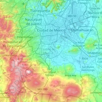
Name: Mexico City topographic map, elevation, terrain.
Location: Mexico City, Mexico (19.04872 -99.36492 19.59276 -98.94030)
Average elevation: 8,593 ft
Minimum elevation: 7,293 ft
Maximum elevation: 12,844 ft
Make a donation
Gear up for your next adventure:
As an Amazon Associate, this site earns from qualifying purchases at no extra cost to you.
Other topographic maps
Click on a map to view its topography, its elevation and its terrain.
Monterrey
Mexico > Nuevo León > Monterrey
The city of Monterrey is 540 metres (1,770 ft) above sea level in the northeastern state of Nuevo León. Monterrey translated literally from Spanish to English is "King Mount" or "King Mountain", and folk etymology claims that this refers to the city's topography and the large mountains that surround it…
Average elevation: 2,470 ft
Tijuana
Mexico > Baja California > Municipio de Tijuana
Housing development in the Tijuana Hills has led to eradication of many seasonal mountain streams. This lack of natural drainage makes places within the city vulnerable to landslides during the rainy season. The varied terrain of Tijuana gives the city elevation extremes that range from sea level to 790 meters…
Average elevation: 463 ft
Make a donation
Gear up for your next adventure:
As an Amazon Associate, this site earns from qualifying purchases at no extra cost to you.
Pico de Orizaba
Mexico > Puebla > Chalchicomula de Sesma
Citlaltépetl (from Náhuatl citlal(in) = star, and tepētl = mountain), otherwise known as Pico de Orizaba, is an active volcano and the highest in North America, as well as the highest mountain in Mexico and third highest peak in North America, after Denali/Mount McKinley of the United States and Mount Logan…
Average elevation: 16,302 ft
Guadalajara
Mexico > Jalisco > Guadalajara
Under the Köppen climate classification, Guadalajara has a humid subtropical climate (Cwa), a temperate climate that is quite close to a tropical climate, featuring dry warm winters and wet, mildly hot summers. Guadalajara's climate is influenced by its high altitude and the general seasonality of…
Average elevation: 5,157 ft
Make a donation
Gear up for your next adventure:
As an Amazon Associate, this site earns from qualifying purchases at no extra cost to you.
Pachuca
Mexico > Hidalgo > Pachuca de Soto
Pachuca has a semi-arid climate (Köppen climate classification BSk). The climate is cool with high rainfall and occasional hail during the summer months and dry conditions during the winter. The coldest month is January, with an average high of 20 °C (68 °F) and an average low of 3 °C (37 °F). Winter…
Average elevation: 8,068 ft
Make a donation
Gear up for your next adventure:
As an Amazon Associate, this site earns from qualifying purchases at no extra cost to you.
Make a donation
Gear up for your next adventure:
As an Amazon Associate, this site earns from qualifying purchases at no extra cost to you.
Make a donation
Gear up for your next adventure:
As an Amazon Associate, this site earns from qualifying purchases at no extra cost to you.
Make a donation
Gear up for your next adventure:
As an Amazon Associate, this site earns from qualifying purchases at no extra cost to you.
Make a donation
Gear up for your next adventure:
As an Amazon Associate, this site earns from qualifying purchases at no extra cost to you.
Make a donation
Gear up for your next adventure:
As an Amazon Associate, this site earns from qualifying purchases at no extra cost to you.
Aguascalientes City
Mexico > Aguascalientes > Municipio de Aguascalientes
The Aguascalientes Bicentenary Velodrome, designed by Peter Junek, hosted the 2010 Pan American Track Championships. At an elevation of 1887m, the Velodrome is a frequent location for attempts at breaking the Cycling Hour Record.
Average elevation: 6,417 ft
Make a donation
Gear up for your next adventure:
As an Amazon Associate, this site earns from qualifying purchases at no extra cost to you.
Monterrey
Mexico > Nuevo León > Monterrey
The city of Monterrey is 540 metres (1,770 ft) above sea level in the northeastern state of Nuevo León. Monterrey translated literally from Spanish to English is "King Mount" or "King Mountain", and folk etymology claims that this refers to the city's topography and the large mountains that surround it…
Average elevation: 2,470 ft
Make a donation
Gear up for your next adventure:
As an Amazon Associate, this site earns from qualifying purchases at no extra cost to you.
Make a donation
Gear up for your next adventure:
As an Amazon Associate, this site earns from qualifying purchases at no extra cost to you.
Culiacán
Culiacán is located in the central region of the State of Sinaloa, forming part of the Northwest of Mexico. The coordinates that correspond to it are 24 ° 48'15 "N (latitude) by 107 ° 25'52" W (West), with an altitude of 54 meters above sea level.
Average elevation: 279 ft
San Francisco del Rincón
Mexico > Guanajuato > San Francisco del Rincón
The settlement was founded as San Francisco del Tule on January 21, 1607 by a group of families of the Purépecha and Hñähñu (Otomi) ethnicities. It was declared a villa (town) on September 6, 1865 and a city on March 27, 1867. It is located at 21°01′22″N 101°51′36″W / 21.02278°N…
Average elevation: 5,797 ft
Acapulco
Mexico > Guerrero > Acapulco de Juárez
The city, located on the Pacific coast of Mexico in the state of Guerrero, is classified as one of the state's seven regions, dividing the rest of the Guerrero coast into the Costa Grande and the Costa Chica. Forty percent of the municipality is mountainous terrain; another forty percent is semi-flat; and the…
Average elevation: 325 ft
Make a donation
Gear up for your next adventure:
As an Amazon Associate, this site earns from qualifying purchases at no extra cost to you.
Make a donation
Gear up for your next adventure:
As an Amazon Associate, this site earns from qualifying purchases at no extra cost to you.
Make a donation
Gear up for your next adventure:
As an Amazon Associate, this site earns from qualifying purchases at no extra cost to you.
Cinco Hermanos (José Luis Alba) [Rancho]
Mexico > Zacatecas > Fresnillo > José María Morelos
Average elevation: 6,696 ft
Make a donation
Gear up for your next adventure:
As an Amazon Associate, this site earns from qualifying purchases at no extra cost to you.
Montemorelos
Mexico > Nuevo León > Montemorelos
In 1637, Governor Martín de Zavala promised a large tract of land in central Nuevo León to Captain Alonso de León on condition that, in less than a year, a colonial settlement is built and populated inside its borders. De León distributed the estate to his children and one of them, Alonso de León…
Average elevation: 1,371 ft
Make a donation
Gear up for your next adventure:
As an Amazon Associate, this site earns from qualifying purchases at no extra cost to you.
Ciudad Obregón
The city is located on the parallel 27–29' north latitude and the meridian 109-59' west longitude. With an altitude above sea level of 40.8 m (134 ft) in the city center.
Average elevation: 194 ft
Chihuahua City
Mexico > Chihuahua > Municipio de Chihuahua
Chihuahua lies on the western side of the Chihuahuan Desert ecoregion and as such has a hot semi-arid climate (Köppen climate classification BSh). However, it is not as hot as most of the lower elevated portions of the desert to the east owing to an altitude of almost 1,500 metres (4,900 feet) above sea level.
Average elevation: 5,102 ft
Make a donation
Gear up for your next adventure:
As an Amazon Associate, this site earns from qualifying purchases at no extra cost to you.
Zapopan
Most of the municipality is flat with another quarter having rolling hills. Altitude varies from 1,500 to 2,000 metres (4,900 to 6,600 ft) above sea level. The main elevations are in the Sierra de la Primavera and include Nejahuete, Tajo, and El Chapulin. Superficial water flows mostly in arroyos east to the…
Average elevation: 5,243 ft
Ajijic
The Chapala Lake basin has a year-round average temperature of about 19 °C (66 °F). Due to Ajijic's tropical latitude and relatively high elevation, it is seldom unpleasantly hot or humid. The rainy season begins in June and lasts until October. The average rainfall is 793 millimetres (31.2 in). Even during…
Average elevation: 5,702 ft
Make a donation
Gear up for your next adventure:
As an Amazon Associate, this site earns from qualifying purchases at no extra cost to you.
Playas de la Vicente Guerrero
Mexico > Baja California > Municipio de San Quintín > Santa Fe
Average elevation: 89 ft
Make a donation
Gear up for your next adventure:
As an Amazon Associate, this site earns from qualifying purchases at no extra cost to you.
Puebla City
Mexico > Puebla > Municipio de Puebla
The Sierra del Tentzon and higher elevations of Malinche volcano still conserve the Trans-Mexican Volcanic Belt pine-oak forests ecoregion – with forests of pine, holm oak and other tree species. In the pine forests, Montezuma Pine (Pinus montezumae) is generally predominant, with Hartweg's Pine (Pinus…
Average elevation: 7,326 ft
Irapuato
Mexico > Guanajuato > Irapuato
It has a hot semi-arid climate (Köppen climate classification: BSh) bordering on a humid subtropical climate (Köppen climate classification: Cwa) with an average temperature of 20 °C (68 °F). The large majority of rainfall occurs from June - September. It is at an altitude above sea level of 1,724 meters…
Average elevation: 5,784 ft
Colonia el Pajarito
Mexico > Oaxaca > Zimatlán de Álvarez > Zimatlán de Álvarez
Average elevation: 4,984 ft
Make a donation
Gear up for your next adventure:
As an Amazon Associate, this site earns from qualifying purchases at no extra cost to you.
Oaxaca City
Mexico > Oaxaca > Oaxaca de Juárez
To counter this, the village petitioned the Crown for elevation to city status, which would grant it certain rights, privileges, and exceptions. It would also ensure that the settlement remained under the king's direct control, rather than Cortés's. This petition was granted in 1532 by Charles V of Spain.
Average elevation: 6,030 ft
San Francisco de la Sierra
Mexico > Baja California Sur > Municipio de Mulegé
Average elevation: 3,802 ft
Zitácuaro
Mexico > Michoacán > Zitácuaro
Zitácuaro stands at 19°26′N 100°22′W / 19.433°N 100.367°W / 19.433; -100.367, in the northeast corner of Michoacán, some 150 km east of state capital Morelia, at an elevation of 1,942 metres above sea level. The municipality covers a total of 498 km2 and is drained by the Río Zitácuaro,…
Average elevation: 7,077 ft
Make a donation
Gear up for your next adventure:
As an Amazon Associate, this site earns from qualifying purchases at no extra cost to you.
Guanajuato City
Mexico > Guanajuato > Municipio de Guanajuato
Although only one out of every 100 bodies interred in the cemetery became naturally mummified, the concentration of this phenomenon has led to theories about how they have come about. Some believe that they are the result of people who had been buried alive, after being mistakenly declared dead. These people,…
Average elevation: 7,159 ft
Make a donation
Gear up for your next adventure:
As an Amazon Associate, this site earns from qualifying purchases at no extra cost to you.
Make a donation
Gear up for your next adventure:
As an Amazon Associate, this site earns from qualifying purchases at no extra cost to you.
Estación de Campo Rio Lagartos de la Reserva de la Biosfera Ria Lagartos
Mexico > Yucatán > Río Lagartos
Average elevation: 13 ft
Make a donation
Gear up for your next adventure:
As an Amazon Associate, this site earns from qualifying purchases at no extra cost to you.
Barrio el Toril Ejido la Soledad
Mexico > State of Mexico > San José del Rincón > San Isidro la Trinidad
Average elevation: 8,862 ft
Make a donation
Gear up for your next adventure:
As an Amazon Associate, this site earns from qualifying purchases at no extra cost to you.