
Tenerife topographic map
Interactive map
Click on the map to display elevation.
Tenerife
Teide National Park, located in the center of the island, is also a UNESCO World Heritage Site. It includes Mount Teide, which has the highest elevation in Spain, and the highest among all the islands in the Atlantic Ocean. It is also the third-largest volcano in the world, when measured from its base. Another geographical feature of the island, the Macizo de Anaga (massif), has been designated as a UNESCO Biosphere Reserve since 2015. Tenerife also has the largest number of endemic species in Europe.
About this map
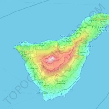
Name: Tenerife topographic map, elevation, terrain.
Location: Tenerife, Canary Islands, Spain (27.99808 -16.92593 28.60540 -16.11938)
Average elevation: 922 ft
Minimum elevation: 0 ft
Maximum elevation: 12,149 ft
Other topographic maps
Click on a map to view its topography, its elevation and its terrain.
Lore-Toki
Spain > Autonomous Community of the Basque Country > Arabako Errioxa/Rioja Alavesa > Labastida/Bastida
Average elevation: 1,637 ft
Coma Breco
Spain > Valencian Community > el Poble Nou de Benitatxell / Benitachell
Average elevation: 482 ft
Maroma
Spain > Andalusia > La Axarquía > Canillas de Aceituno
La Maroma, also known as Tejeda, at an altitude of 2069 m, is the highest peak of the Sierra de Tejeda, Penibaetic System, Spain. The summit is located in the region of Axarquía on the border between the provinces of Granada and Málaga.
Average elevation: 5,597 ft
Praia de Baldaio - As Saíñas
Spain > Galicia > Bergantiños > Carballo > A Pedra do Sal
Average elevation: 43 ft
Alhambra
Spain > Andalusia > Partido Judicial de Granada > Granada
During the reign of the Nasrid Dynasty, the Alhambra was transformed into a palatine city, complete with an irrigation system composed of aqueducts and water channels that provided water for the complex and for other nearby countryside palaces such as the Generalife. Previously, the old fortresses on the hill…
Average elevation: 2,490 ft
Castillo de Piedrabuena
Spain > Extremadura > Tierra de Badajoz > San Vicente de Alcántara > Dehesa Piedrabuena
Average elevation: 1,194 ft
Raiguero de Bonanza
Spain > Valencian Community > el Baix Segura / La Vega Baja > Orihuela
Average elevation: 456 ft
Parc Forestal de l'Ermita del Pla de Sant Joan
Spain > Catalonia > Baix Llobregat > la Palma de Cervelló > Urbanització Can Vidal
Average elevation: 417 ft
Platja d'Aro
Spain > Catalonia > Lower Empordà > Castell d'Aro, Platja d'Aro i s'Agaró
Average elevation: 154 ft
Alhambra
Spain > Andalusia > Partido Judicial de Granada > Granada
During the reign of the Nasrid Dynasty, the Alhambra was transformed into a palatine city, complete with an irrigation system composed of aqueducts and water channels that provided water for the complex and for other nearby countryside palaces such as the Generalife. Previously, the old fortresses on the hill…
Average elevation: 2,490 ft
Flysch
Spain > Autonomous Community of the Basque Country > Urola-Kosta > Zumaia
Average elevation: 89 ft
Barinatxe - La Salvaje
Spain > Autonomous Community of the Basque Country > Sopela
Average elevation: 85 ft
Torrea
Spain > Autonomous Community of the Basque Country > Debabarrena > Eibar
Average elevation: 1,306 ft
La Maliciosa
Spain > Community of Madrid > Navacerrada
La Maliciosa is one of the most important and highest mountains of the Sierra de Guadarrama, a mountainous formation belonging to the Sistema Central. It has an altitude of 2227m above sea level and is located in the northwest of the Community of Madrid, in Spain, rising between La Pedriza, which lies to the…
Average elevation: 6,089 ft