
Atlantic County topographic map
Click on the map to display elevation.
Atlantic County
The county lies along the Atlantic Coastal Plain, with sea level and the Atlantic Ocean to the east. Adjacent to the coast are three barrier islands – Absecon Island (Which contains Atlantic City, Ventnor, Margate, and Longport), Brigantine Island, and Little Beach. To the west of the barrier islands, 4 mi (6 km) stretch of marshlands, inlets, and waterways connect and form the Intracoastal Waterway. Beneath the county is a mile of clay and sand that contains the Kirkwood–Cohansey aquifer, which supplies fresh groundwater for all of the streams and rivers in the region. The interior of the county is part of the Pine Barrens, which covers the southern third of New Jersey, and is prone to forest fires. Lowland areas are swampy and contain pitch pine or white cedar trees. Upland areas in the west of the county are hilly, containing oak and pine trees. The highest elevation in the county – about 150 ft (46 m) above sea level – is found near the border with Camden County, just west of Hammonton. The county's western boundary with Burlington and Camden counties, clarified in 1761, is a manmade line about halfway between the Atlantic Ocean and the Delaware Bay.
About this map
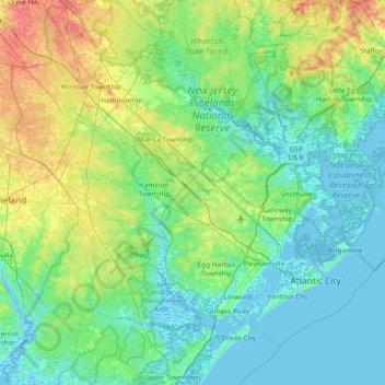
Name: Atlantic County topographic map, elevation, terrain.
Location: Atlantic County, New Jersey, United States (39.26205 -74.98522 39.72991 -74.23182)
Average elevation: 49 ft
Minimum elevation: -13 ft
Maximum elevation: 210 ft
New Jersey trails, hiking, mountain biking, running and outdoor activities
Other topographic maps
Click on a map to view its topography, its elevation and its terrain.
Bishops
United States > New Jersey > Camden County > Waterford Township > Atco
Average elevation: 154 ft
Kenvil
United States > New Jersey > Morris County > Roxbury Township > Succasunna
Average elevation: 784 ft
Raven Rock
United States > New Jersey > Hunterdon County > Delaware Township
Average elevation: 285 ft
Centerville
United States > New Jersey > Hunterdon County > Readington Township
Average elevation: 161 ft
North Stelton
United States > New Jersey > Middlesex County > Piscataway Township
Average elevation: 95 ft
Washington Valley
United States > New Jersey > Morris County > Morris Township
Average elevation: 499 ft
High Rock Mountain
United States > New Jersey > Warren County > White Township
Average elevation: 620 ft
Downs Farms
United States > New Jersey > Camden County > Cherry Hill Township
Average elevation: 79 ft
Basking Ridge
United States > New Jersey > Somerset County > Bernards Township
Average elevation: 322 ft
Lincoln
United States > New Jersey > Gloucester County > South Harrison Township
Average elevation: 121 ft
Freneau Woods Park
United States > New Jersey > Monmouth County > Aberdeen Township > Henningers Mill
Average elevation: 75 ft
Croxton
United States > New Jersey > Hudson County > Jersey City > Journal Square
Average elevation: 52 ft
Echo Lake Park
United States > New Jersey > Monmouth County > Howell Township
Average elevation: 85 ft
Ringoes
United States > New Jersey > Hunterdon County > East Amwell Township
Average elevation: 246 ft
Frost Woods Park
United States > New Jersey > Middlesex County > East Brunswick Township
Average elevation: 95 ft
Monroeville
United States > New Jersey > Salem County > Upper Pittsgrove Township
Average elevation: 131 ft
Hampton Gate
United States > New Jersey > Burlington County > Tabernacle Township
Average elevation: 79 ft
Sunset Beach
United States > New Jersey > Gloucester County > Deptford Township
Average elevation: 56 ft
East Riverton
United States > New Jersey > Burlington County > Cinnaminson Township > Riverton
Average elevation: 30 ft
Town Brook
United States > New Jersey > Monmouth County > Middletown Township
Average elevation: 89 ft
Barnegat Beach
United States > New Jersey > Ocean County > Ocean Township > Waretown
Average elevation: 13 ft
Township of Wayne McCoog Park
United States > New Jersey > Passaic County > Wayne
Average elevation: 180 ft
Springtown
United States > New Jersey > Cumberland County > Greenwich Township
Average elevation: 39 ft
Green Curve Heights
United States > New Jersey > Mercer County > Ewing Township
Average elevation: 131 ft
High Point
United States > New Jersey > Sussex County > Montague Township
High Point is a mountain peak within High Point State Park on the border of Wantage Township and Montague Township, Sussex County, New Jersey. Located in the portion of the state known as the Skylands, it is the highest elevation in the state, with a peak elevation of 1,803 feet (550 m). The closest city is…
Average elevation: 1,362 ft
Creesville
United States > New Jersey > Gloucester County > Washington Township
Average elevation: 105 ft
Middlesex Downs
United States > New Jersey > Middlesex County > Monroe Township
Average elevation: 108 ft