
Make a donation
Gear up for your next adventure:
As an Amazon Associate, this site earns from qualifying purchases at no extra cost to you.
Pisgah National Forest topographic map
Click on the map to display elevation.
Make a donation
Gear up for your next adventure:
As an Amazon Associate, this site earns from qualifying purchases at no extra cost to you.
Pisgah National Forest
The Pisgah National Forest covers 512,758 acres (801 sq mi; 2,075 km2) of mountainous terrain in the southern Appalachian Mountains, including parts of the Blue Ridge Mountains and Great Balsam Mountains. Elevations reach over 6,000 feet (1,800 m) and include some of the highest mountains in the eastern United States. Summit elevations include Black Balsam Knob at 6,214 feet (1,894 m), Mount Hardy at 6,110 feet (1,860 m), Tennant Mountain at 6,056 feet (1,846 m), and Cold Mountain at 6,030 feet (1,840 m). Mount Mitchell, in Mount Mitchell State Park, is the highest mountain east of the Mississippi River and lies just outside the boundary of Pisgah National Forest.
Make a donation
Gear up for your next adventure:
As an Amazon Associate, this site earns from qualifying purchases at no extra cost to you.
About this map
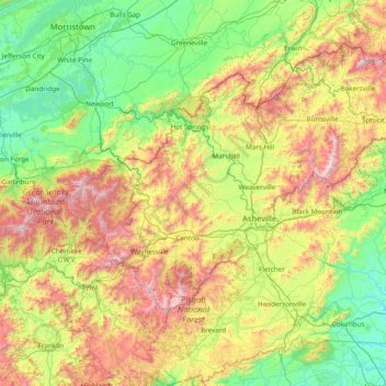
Name: Pisgah National Forest topographic map, elevation, terrain.
Average elevation: 2,467 ft
Minimum elevation: 771 ft
Maximum elevation: 6,624 ft
Buncombe County trails, hiking, mountain biking, running and outdoor activities
Make a donation
Gear up for your next adventure:
As an Amazon Associate, this site earns from qualifying purchases at no extra cost to you.
Other topographic maps
Click on a map to view its topography, its elevation and its terrain.
Make a donation
Gear up for your next adventure:
As an Amazon Associate, this site earns from qualifying purchases at no extra cost to you.
Make a donation
Gear up for your next adventure:
As an Amazon Associate, this site earns from qualifying purchases at no extra cost to you.
Rainbow Mountain
United States > North Carolina > Buncombe County > Montreat
Average elevation: 2,858 ft
Make a donation
Gear up for your next adventure:
As an Amazon Associate, this site earns from qualifying purchases at no extra cost to you.
Murphy Junction
United States > North Carolina > Buncombe County > Asheville
Average elevation: 2,106 ft
Make a donation
Gear up for your next adventure:
As an Amazon Associate, this site earns from qualifying purchases at no extra cost to you.
Make a donation
Gear up for your next adventure:
As an Amazon Associate, this site earns from qualifying purchases at no extra cost to you.
Parkway Forest
United States > North Carolina > Buncombe County > Asheville
Average elevation: 2,241 ft
Make a donation
Gear up for your next adventure:
As an Amazon Associate, this site earns from qualifying purchases at no extra cost to you.
Highland Gate
United States > North Carolina > Buncombe County > Asheville
Average elevation: 2,320 ft
Make a donation
Gear up for your next adventure:
As an Amazon Associate, this site earns from qualifying purchases at no extra cost to you.
Sulphur Springs
United States > North Carolina > Buncombe County > Asheville
Average elevation: 2,169 ft
Make a donation
Gear up for your next adventure:
As an Amazon Associate, this site earns from qualifying purchases at no extra cost to you.
Boswell
United States > North Carolina > Buncombe County > Asheville > Boswell
Average elevation: 2,159 ft
Make a donation
Gear up for your next adventure:
As an Amazon Associate, this site earns from qualifying purchases at no extra cost to you.
Sayles Village
United States > North Carolina > Buncombe County > Asheville
Average elevation: 2,129 ft
Malvern Hills
United States > North Carolina > Buncombe County > Asheville
Average elevation: 2,116 ft
Make a donation
Gear up for your next adventure:
As an Amazon Associate, this site earns from qualifying purchases at no extra cost to you.