
Gaston topographic map
Interactive map
Click on the map to display elevation.
About this map
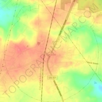
Name: Gaston topographic map, elevation, terrain.
Location: Gaston, Lexington County, South Carolina, United States (33.80213 -81.11859 33.83415 -81.08299)
Average elevation: 456 ft
Minimum elevation: 315 ft
Maximum elevation: 538 ft
Lexington County trails, hiking, mountain biking, running and outdoor activities
Other topographic maps
Click on a map to view its topography, its elevation and its terrain.
Coventry Woods
United States > South Carolina > Lexington County > Lexington
Average elevation: 351 ft
Peachtree Rock Heritage Preserve
United States > South Carolina > Lexington County
Average elevation: 486 ft
Batesburg
United States > South Carolina > Lexington County > Batesburg-Leesville
Average elevation: 610 ft
Edenwood
United States > South Carolina > Lexington County > Cayce > Edenwood
Average elevation: 167 ft