
Peachtree Rock Heritage Preserve topographic map
Interactive map
Click on the map to display elevation.
About this map
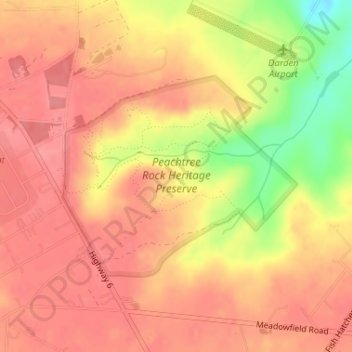
Name: Peachtree Rock Heritage Preserve topographic map, elevation, terrain.
Average elevation: 486 ft
Minimum elevation: 295 ft
Maximum elevation: 561 ft
Other topographic maps
Click on a map to view its topography, its elevation and its terrain.
Saint Andrews
United States > South Carolina > Lexington County
Saint Andrews, Lexington County, South Carolina, 29210, United States
Average elevation: 249 ft
Lake Murray
United States > South Carolina > Lexington County
Lake Murray, Lexington County, South Carolina, United States
Average elevation: 371 ft
Oak Grove
United States > South Carolina > Lexington County > Lakeview Terrace
Oak Grove, Lakeview Terrace, Lexington County, South Carolina, United States
Average elevation: 318 ft
South Congaree
United States > South Carolina > Lexington County
South Congaree, Lexington County, South Carolina, United States
Average elevation: 213 ft
Glenn Village
United States > South Carolina > Lexington County
Glenn Village, Lexington County, South Carolina, 29172, United States
Average elevation: 308 ft
Shady Acres
United States > South Carolina > Lexington County
Shady Acres, Lexington County, South Carolina, 29036, United States
Average elevation: 377 ft
Gilbert
United States > South Carolina > Lexington County
Gilbert, Lexington County, South Carolina, United States
Average elevation: 538 ft
West Columbia
United States > South Carolina > Lexington County
West Columbia, Lexington County, South Carolina, United States
Average elevation: 230 ft
Pelion
United States > South Carolina > Lexington County
Pelion, Lexington County, South Carolina, 29123, United States
Average elevation: 420 ft
Chapin
United States > South Carolina > Lexington County
Chapin, Lexington County, South Carolina, United States
Average elevation: 436 ft
Batesburg
United States > South Carolina > Lexington County > Batesburg-Leesville
Batesburg, Batesburg-Leesville, Lexington County, South Carolina, 29060, United States
Average elevation: 610 ft
Swansea
United States > South Carolina > Lexington County
Swansea, Lexington County, South Carolina, United States
Average elevation: 384 ft
Irmo
United States > South Carolina > Lexington County
Irmo, Lexington County, South Carolina, 29212, United States
Average elevation: 308 ft
Chapin
United States > South Carolina > Lexington County > Chapin
Chapin, Lexington County, South Carolina, 29075, United States
Average elevation: 423 ft
Walden
United States > South Carolina > Lexington County
Walden, Lexington County, South Carolina, 29212, United States
Average elevation: 259 ft
Lexington
United States > South Carolina > Lexington County
Lexington, Lexington County, South Carolina, United States
Average elevation: 377 ft
Cayce
United States > South Carolina > Lexington County > Cayce
Cayce, Lexington County, South Carolina, 29033, United States
Average elevation: 272 ft
Pine Point
United States > South Carolina > Lexington County > Pine Point
Pine Point, Lexington County, South Carolina, United States
Average elevation: 407 ft
Edenwood
United States > South Carolina > Lexington County > Cayce > Edenwood
Edenwood, Cayce, Lexington County, South Carolina, 29033, United States
Average elevation: 167 ft
Batesburg-Leesville
United States > South Carolina > Lexington County
Batesburg-Leesville, Lexington County, South Carolina, 29060, United States
Average elevation: 584 ft
Gaston
United States > South Carolina > Lexington County
Gaston, Lexington County, South Carolina, United States
Average elevation: 456 ft
Cayce
United States > South Carolina > Lexington County
Cayce, Lexington County, South Carolina, 29033, United States
Average elevation: 210 ft