
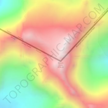
Mount Cook topographic map
Interactive map
Click on the map to display elevation.
About this map
Name: Mount Cook topographic map, elevation, terrain.
Location: Mount Cook, Yukon, Unorganized, Yukon, Canada (60.18372 -139.98444 60.18382 -139.98434)
Average elevation: 11,781 ft
Minimum elevation: 9,524 ft
Maximum elevation: 13,740 ft
Other topographic maps
Click on a map to view its topography, its elevation and its terrain.
Dawson City
The community is at an elevation of 320 m (1,050 ft) and the average rainfall in July is 49.0 mm (1.93 in) and the average snowfall in January is 27.6 cm (10.87 in). Dawson has an average total annual snowfall of 166.5 cm (65.55 in) and averages 70 frost free days per year. The town is built on a layer of…
Average elevation: 1,663 ft