
Clinton County topographic map
Click on the map to display elevation.
About this map
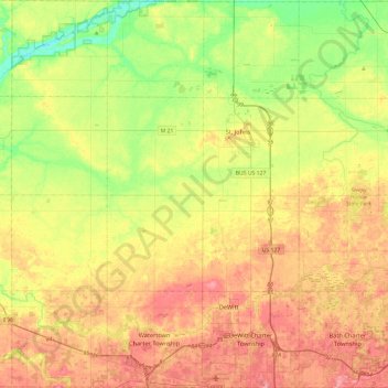
Name: Clinton County topographic map, elevation, terrain.
Location: Clinton County, Michigan, United States (42.76947 -84.83762 43.11883 -84.36354)
Average elevation: 774 ft
Minimum elevation: 630 ft
Maximum elevation: 925 ft
Michigan trails, hiking, mountain biking, running and outdoor activities
Other topographic maps
Click on a map to view its topography, its elevation and its terrain.
Grand Mere State Park
United States > Michigan > Berrien County > Lincoln Charter Township
Average elevation: 607 ft
Metamora-Hadley State Recreation Area
United States > Michigan > Lapeer County > Metamora
Average elevation: 978 ft
Merriweather
United States > Michigan > Ontonagon County > Bergland Township
Average elevation: 1,339 ft
Green Oak
United States > Michigan > Livingston County > Green Oak Charter Township
Average elevation: 902 ft
Elk Lake
United States > Michigan > Lapeer County > Attica Township > Attica
Average elevation: 889 ft
Boyne Mountain
United States > Michigan > Charlevoix County > Boyne Valley Township
Average elevation: 863 ft
Anchor Bay Shores
United States > Michigan > Macomb County > Chesterfield Township
Average elevation: 577 ft
Lookout Point
United States > Michigan > Grand Traverse County > Peninsula Township
Average elevation: 617 ft
Old Mission
United States > Michigan > Grand Traverse County
Old Mission is located just east of M-37 near the tip of Old Mission Peninsula about 16 miles (25.75 km) north of Traverse City. The community was built along Old Mission Harbor, which is a small safe haven along the East Arm of Grand Traverse Bay. The community sits at an elevation of 587 feet (179 m) above…
Average elevation: 623 ft
Genessee County Recreational Area
United States > Michigan > Genesee County > Genesee Charter Township
Average elevation: 758 ft
Whitefish Point
United States > Michigan > Chippewa County > Whitefish Township
Average elevation: 587 ft
Mount Arvon
United States > Michigan > Baraga County > L'Anse Township
Mount Arvon (/ɑːrvɒn/ ARR-vahn) at 1,979 feet (603 m), is the highest natural point in the U.S. state of Michigan. Located in L'Anse Township, Baraga County, Mount Arvon is part of the Huron Mountains. It rises about eight miles (13 km) south of Lake Superior (elevation 591 feet [180 m]). On the list of…
Average elevation: 1,726 ft
Charlevoix South Pier Light
United States > Michigan > Charlevoix County > Charlevoix
Average elevation: 591 ft
Lower Peninsula Experimental Forest
United States > Michigan > Wexford County > South Branch Township
Average elevation: 1,030 ft
Echo Lake
United States > Michigan > Kent County > Grand Rapids Charter Township
Average elevation: 787 ft
Falmouth
United States > Michigan > Missaukee County > Clam Union Township
Average elevation: 1,191 ft
Christie Lake
United States > Michigan > Van Buren County > Lawrence Township
Average elevation: 781 ft
Mcnearney Lake
United States > Michigan > Chippewa County > Bay Mills Township
Average elevation: 938 ft
Edgewater Beach
United States > Michigan > Cheboygan County > Mackinaw Township
Average elevation: 614 ft
Sebawaing River
United States > Michigan > Huron County > Sebewaing Township
Average elevation: 597 ft
Silver City
United States > Michigan > Ontonagon County > Carp Lake Township
Average elevation: 617 ft
Cambridge Junction
United States > Michigan > Lenawee County > Cambridge Township
Average elevation: 1,001 ft
New Hudson
United States > Michigan > Oakland County > Lyon Charter Township
Average elevation: 951 ft
Centennial Heights
United States > Michigan > Houghton County > Calumet Township
Average elevation: 1,194 ft