
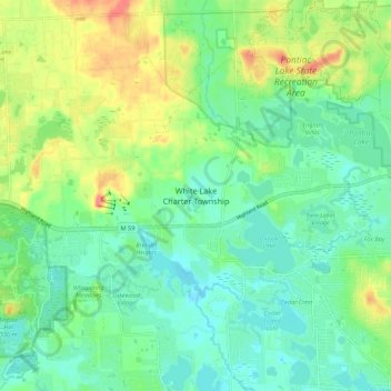
White Lake Charter Township topographic map
Interactive map
Click on the map to display elevation.
About this map
Name: White Lake Charter Township topographic map, elevation, terrain.
Average elevation: 991 ft
Minimum elevation: 909 ft
Maximum elevation: 1,165 ft
Oakland County trails, hiking, mountain biking, running and outdoor activities
Other topographic maps
Click on a map to view its topography, its elevation and its terrain.
Kent Lake
United States > Michigan > Oakland County > Milford Charter Township
Average elevation: 951 ft
Carpenter Lake Nature Preserve
United States > Michigan > Oakland County > Southfield
Average elevation: 679 ft
Waterbury Lake
United States > Michigan > Oakland County > Highland Charter Township
Average elevation: 1,010 ft
Veterans Park
United States > Michigan > Oakland County > Highland Charter Township
Average elevation: 1,017 ft
Independence Charter Township
United States > Michigan > Oakland County
Independence Township is located along the Hillsdale-Lapeer Moraine Range. The highest hill along that range in Independence Township is Pine Knob, at 1,221 feet. It is also the highest point in Southeastern Michigan. Only three miles away is Waterford Hill, the second highest hill in Independence Township…
Average elevation: 1,043 ft
Round Lake
United States > Michigan > Oakland County > Orion Charter Township
Average elevation: 994 ft
Highland State Recreation Area
United States > Michigan > Oakland County > Highland
West of Duck Lake Road in Highland State Recreation Area, a group of small moraines are locally called "mountains"—the highest elevation in the park, Mount Kanzer, is 1,150 feet (350 m) above sea level. The highland for which this recreation area is named is this group of moraines.
Average elevation: 991 ft
Loon Lake
United States > Michigan > Oakland County > Waterford Township > Clintonville
Average elevation: 965 ft
Depot Park
United States > Michigan > Oakland County > Village of Clarkston
Average elevation: 1,010 ft
Oxford
United States > Michigan > Oakland County > Oxford Charter Township
Average elevation: 1,047 ft